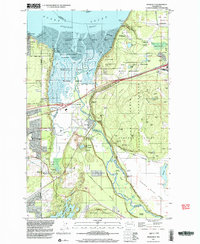
1997 Map of Nisqually
USGS Topo · Published 2003About this map
The Nisqually River delta defines this landscape at the turn of the millennium, where the river meets the Nisqually Reach of Puget Sound. Large portions of the terrain are dedicated to conservation and military use, specifically the Nisqually National Wildlife Refuge and the sprawling Fort Lewis Military Reservation. For the local historian, the map preserves the locations of two distinct early trading outposts: the Fort Nisqually 1833 Historical Site near the DuPont Wharf and the Fort Nisqually 1843 Historical Site further inland. The transition from industrial and military history to modern environmental stewardship is visible across the Nisqually Flats. Settlement patterns are concentrated near Beachcrest and the village of Nisqually, while the inland area is marked by numerous named peaks like Monette Hill and Atkins Hill within the Argonne Forest.
Find a feature on this map
68 named features on this map. Tap any name to fly to it.
Don’t see what you’re looking for? This feature index may not catch every label — zoom into the map to look around manually.
Map Details
Editions of this 1997 Nisqually Map
This is the sole edition of this map. No revisions or reprints were ever made.
Other maps of this area

1916 · Chehalis
USGS Topo · 1:125,000

1937 · Olympia
USGS Topo · 1:62,500

1940 · Tenino
USGS Topo · 1:62,500

1940 · Anderson Island
USGS Topo · 1:62,500

1944 · Tenino
USGS Topo · 1:62,500

1944 · Yelm
USGS Topo · 1:62,500

1948 · Anderson Island
USGS Topo · 1:62,500

1948 · Fort Lewis
USGS Topo · 1:24,000

1948 · Nisqually
USGS Topo · 1:24,000

1948 · Anderson Island
USGS Topo · 1:24,000