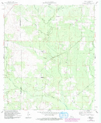
1959 Map of Grant
USGS Topo · Published 1993About this map
The settlement of Grant lies at the heart of this landscape, situated along the boundary between Beauregard and Allen Parish. The area is defined by a dense network of watercourses, most notably Whisky Chitto Creek and Tenmile Creek, which drain the timbered terrain. Small rural congregations and family burial grounds are frequent throughout the region, including Arkadelphia Ch, Hopewell Ch, and Palestine Ch. Genealogy researchers will find several well-defined sites such as Hamilton Cem and Horton Cem near the parish lines. The presence of a Gaging Station and a localized Gravel Pit indicates the minor industrial and hydrologic monitoring active during this mid-century period. The topography is marked by numerous small tributaries like Sixmile Branch and Sugar Creek, illustrating the complex drainage patterns of the Louisiana piney woods before later 20th-century developments.
Find a feature on this map
24 named features on this map. Tap any name to fly to it.
Don’t see what you’re looking for? This feature index may not catch every label — zoom into the map to look around manually.
Map Details
Editions of this 1959 Grant Map
3 editions found
Other maps of this area

1935 · Mittie
USGS Topo · 1:31,680

1947 · Steep Gully
USGS Topo · 1:31,680

1947 · Pine Chapel
USGS Topo · 1:31,680

1947 · Elizabeth
USGS Topo · 1:31,680

1947 · Grant
USGS Topo · 1:31,680

1947 · Bundick
USGS Topo · 1:31,680

1947 · Sugartown
USGS Topo · 1:31,680

1947 · Sugrue
USGS Topo · 1:31,680

1947 · Pitkin
USGS Topo · 1:31,680

1948 · Grant
USGS Topo · 1:24,000