1989 Map of Salt Canyon
USGS Topo · Published 1989About this map
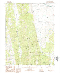
Cortina Rancheria Indian Reservation lies at the southern heart of this landscape, an area defined by the sharp rise of Cortina Ridge. The terrain transitions between the open flats of Spring Valley to the east and Antelope Valley to the west, separated by a complex network of canyons and named high points. Local landmarks like Whiskey Hill and Helmer Hill suggest a history of grazing and ranching, supported by a series of essential water sources including Britton Spring and Cottonwood Spring.
Find a feature on this map
44 named features on this map. Tap any name to fly to it.
Don’t see what you’re looking for? This feature index may not catch every label — zoom into the map to look around manually.
Map Details
Editions of this 1989 Salt Canyon Map
2 editions found
Historical Maps of Colusa County Through Time
79 maps found

1904 Sites
Colusa County, CA

1905 Fairview
Colusa County, CA

1905 Harrington
Colusa County, CA

1911 Sanborn Slough
Colusa County, CA

1916 Harrington
Colusa County, CA

1916 Hershey
Colusa County, CA

1917 Compton Landing
Colusa County, CA

1917 Delevan
Colusa County, CA

1917 Sites
Colusa County, CA

1918 Powell Slough
Colusa County, CA

1918 Spring Valley
Colusa County, CA

1920 Venado
Colusa County, CA

1944 Wilbur Springs
Colusa County, CA

1952 Moulton Weir
Colusa County, CA

1952 Sanborn Slough
Colusa County, CA

1953 Cortina Creek
Colusa County, CA

1958 Glascock Mtn
Colusa County, CA

1958 Manor Slough
Colusa County, CA

1958 Sites
Colusa County, CA

1959 Wildwood School
Colusa County, CA

1961 Wilbur Springs
Colusa County, CA

1968 Fouts Springs
Colusa County, CA

1968 Gilmore Peak
Colusa County, CA

1989 Leesville
Colusa County, CA

1989 Salt Canyon
Colusa County, CA

1989 Wilbur Springs
Colusa County, CA

1991 Moulton Weir
Colusa County, CA

1991 Wilbur Springs
Colusa County, CA

1996 Fouts Springs
Colusa County, CA

1996 Gilmore Peak
Colusa County, CA

2012 Cortina Creek
Colusa County, CA

2012 Fouts Springs
Colusa County, CA

2012 Gilmore Peak
Colusa County, CA

2012 Glascock Mountain
Colusa County, CA

2012 Leesville
Colusa County, CA

2012 Manor Slough
Colusa County, CA

2012 Moulton Weir
Colusa County, CA

2012 Salt Canyon
Colusa County, CA

2012 Sanborn Slough
Colusa County, CA

2012 Sites
Colusa County, CA

2012 Wilbur Springs
Colusa County, CA

2012 Wildwood School
Colusa County, CA

2015 Cortina Creek
Colusa County, CA

2015 Fouts Springs
Colusa County, CA

2015 Gilmore Peak
Colusa County, CA

2015 Glascock Mountain
Colusa County, CA

2015 Leesville
Colusa County, CA

2015 Manor Slough
Colusa County, CA

2015 Moulton Weir
Colusa County, CA

2015 Salt Canyon
Colusa County, CA

2015 Sanborn Slough
Colusa County, CA

2015 Sites
Colusa County, CA

2015 Wilbur Springs
Colusa County, CA

2015 Wildwood School
Colusa County, CA

2018 Cortina Creek
Colusa County, CA

2018 Fouts Springs
Colusa County, CA

2018 Gilmore Peak
Colusa County, CA

2018 Glascock Mountain
Colusa County, CA

2018 Leesville
Colusa County, CA

2018 Manor Slough
Colusa County, CA

2018 Moulton Weir
Colusa County, CA

2018 Salt Canyon
Colusa County, CA

2018 Sanborn Slough
Colusa County, CA

2018 Sites
Colusa County, CA

2018 Wilbur Springs
Colusa County, CA

2018 Wildwood School
Colusa County, CA

2021 Cortina Creek
Colusa County, CA

2021 Fouts Springs
Colusa County, CA

2021 Gilmore Peak
Colusa County, CA

2021 Glascock Mountain
Colusa County, CA

2021 Manor Slough
Colusa County, CA

2021 Moulton Weir
Colusa County, CA

2021 Salt Canyon
Colusa County, CA

2021 Sanborn Slough
Colusa County, CA

2021 Sites
Colusa County, CA

2021 Wildwood School
Colusa County, CA

2022 Leesville
Colusa County, CA

2022 Wilbur Springs
Colusa County, CA

2024 Wilbur Springs
Colusa County, CA