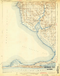
1943 Map of Weeks Bay
USGS Topo · Published 1943This historical map portrays the area of Weeks Bay in 1943, primarily covering Baldwin County. Featuring a scale of 1:62500, this map provides a highly detailed snapshot of the terrain, roads, buildings, counties, and historical landmarks in the Weeks Bay region at the time. Published in 1943, it is one of 4 known editions of this map due to revisions or reprints.
Map Details
Editions of this 1943 Weeks Bay Map
4 editions found
Historical Maps of Fairhope Through Time
40 maps found

1941 Blakeley
Baldwin County, AL

1941 Weeks Bay
Baldwin County, AL

1942 Blakeley
Baldwin County, AL

1942 Dyas
Baldwin County, AL

1942 Hurricane
Baldwin County, AL

1943 Blakeley
Baldwin County, AL

1943 Hurricane
Baldwin County, AL

1943 Tensaw
Baldwin County, AL

1943 Weeks Bay
Baldwin County, AL

1944 Dyas
Baldwin County, AL

1944 Miflin
Baldwin County, AL

1944 Muscogee
Baldwin County, AL

1944 Tensaw
Baldwin County, AL

1953 Bridgehead
Baldwin County, AL

1953 Hurricane
Baldwin County, AL

1958 Fort Morgan
Baldwin County, AL

1978 Dogwood Creek
Baldwin County, AL

1978 Dyas
Baldwin County, AL

1978 Gateswood
Baldwin County, AL

1978 Seminole
Baldwin County, AL

1980 Bay Minette North
Baldwin County, AL

1980 Bay Minette South
Baldwin County, AL

1980 Bon Secour Bay
Baldwin County, AL

1980 Elsanor
Baldwin County, AL

1980 Little Point Clear
Baldwin County, AL

1980 Pine Beach
Baldwin County, AL

1980 St. Andrews Bay
Baldwin County, AL

1980 Steelwood Lake
Baldwin County, AL

1980 The Basin
Baldwin County, AL

1983 Bilbo Island
Baldwin County, AL

1983 Blacksher
Baldwin County, AL

1983 Stiggings Lake
Baldwin County, AL

1983 Tensaw
Baldwin County, AL

1983 Vaughn
Baldwin County, AL

1986 Bay Minette North
Baldwin County, AL

1994 Dogwood Creek
Baldwin County, AL

1994 Dyas
Baldwin County, AL

1994 Gateswood
Baldwin County, AL

1997 Hurricane
Baldwin County, AL

2003 Dyas
Baldwin County, AL