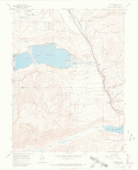
1967 Map of Granite
USGS Topo · Published 1972About this map
Arkansas River flows southward through the heart of this high-elevation landscape, where the waters of the Twin Lakes Reservoir and Clear Creek Reservoir dominate the local geography. The settlement of Granite sits along the river at the intersection of industry and transportation, serving as a focal point near the Lake Co Chaffee Co boundary. The area's extraction history is visible through the Columbine Mine, various Placer Mines, and numerous prospects scattered across the surrounding slopes. Transportation follows the rugged river corridor, notably via the Denver and Rio Grande Western Railroad, while the Main Range Trail (Pack) indicates the more primitive routes used to navigate the San Isabel National Forest. Local genealogists will find the Granite Cem and small settlements like Kobe and Balltown helpful for placing families within this mountainous terrain.
Find a feature on this map
45 named features on this map. Tap any name to fly to it.
Don’t see what you’re looking for? This feature index may not catch every label — zoom into the map to look around manually.
Map Details
Editions of this 1967 Granite Map
3 editions found
Other maps of this area

1889 · Leadville
USGS Topo · 1:125,000

1891 · Leadville
USGS Topo · 1:125,000

1935 · Mount Elbert
USGS Topo · 1:62,500

1938 · Mount Elbert
USGS Topo · 1:62,500

1939 · Mount Elbert
USGS Topo · 1:62,500

1942 · Leadville
USGS Topo · 1:125,000

1955 · Buena Vista
USGS Topo · 1:62,500

1955 · Mount Harvard
USGS Topo · 1:62,500

1956 · Montrose
USGS Topo · 1:250,000

1957 · Leadville
USGS Topo · 1:250,000