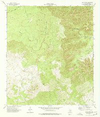
1974 Map of Kelley Peak
USGS Topo · Published 1977About this map
Kelley Peak rises as a prominent landmark in this segment of the Texas Hill Country, documented by the Texas Water Development Board and the U.S. Geological Survey. The landscape is defined by an intricate network of seasonal drainages and springs, including Winans Spring and Pecan Spring, which were vital water sources in this arid Edwards County environment. The map captures a primarily rural and ranch-oriented topography where movement is dictated by the winding courses of Sycamore Creek and several Jeep Trails. A small Cem and a Gravel Pit near the creek beds point to localized historical land use and early resource extraction. The density of contour lines illustrates the sharp relief typical of the Balcones Escarpment's western edges, where features like Rock Hollow and Rough Sycamore Creek carve through the limestone plateau.
Find a feature on this map
15 named features on this map. Tap any name to fly to it.
Don’t see what you’re looking for? This feature index may not catch every label — zoom into the map to look around manually.
Map Details
Editions of this 1974 Kelley Peak Map
This is the sole edition of this map. No revisions or reprints were ever made.
Other maps of this area

1893 · Nueces
USGS Topo · 1:125,000

1896 · Nueces
USGS Topo · 1:125,000

1944 · Barksdale
USGS Topo · 1:62,500

1944 · Indian Creek
USGS Topo · 1:62,500

1944 · Indian Mountain
USGS Topo · 1:62,500

1947 · Hackberry
USGS Topo · 1:62,500

1958 · Del Rio
USGS Topo · 1:250,000

1964 · Del Rio
USGS Topo · 1:250,000
1967 · Indian Mountain
USGS Topo · 1:24,000
1973 · Montell
USGS Topo · 1:24,000