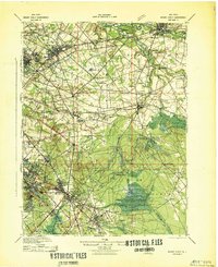
1942 Map of Mount Holly
USGS Topo · Published 1942About this map
The Rancocas Creek and its many branches form the primary drainage system for this part of south-central New Jersey, dictating the placement of early industry and transport. Throughout the lowlands of Mount Laurel and Lumberton, numerous family-named mills such as Union Mills, Kirbys Mill, and Tomlinsons Mill indicate a landscape still closely tied to local hydraulic power. Further south, the transition into the Pine Barrens is evident near Bear Swamp, where the West Jersey Cranberry Meadow highlights the specialized agricultural economy of the Mullica River basin.
Find a feature on this map
137 named features on this map. Tap any name to fly to it.
Don’t see what you’re looking for? This feature index may not catch every label — zoom into the map to look around manually.
Map Details
Editions of this 1942 Mount Holly Map
This is the sole edition of this map. No revisions or reprints were ever made.
Other maps of this area

1888 · Bordentown
USGS Topo · 1:62,500

1888 · Pemberton
USGS Topo · 1:62,500

1888 · Mount Holly
USGS Topo · 1:62,500

1890 · Hammonton
USGS Topo · 1:62,500

1890 · Burlington
USGS Topo · 1:62,500

1890 · Mullica
USGS Topo · 1:62,500

1890 · Glassboro
USGS Topo · 1:62,500

1891 · Philadelphia
USGS Topo · 1:62,500

1893 · Germantown
USGS Topo · 1:62,500

1893 · Bordentown
USGS Topo · 1:62,500
Featured Places
- Cherry Hill Township, NJ
- Mount Laurel Township, NJ
- Winslow Township, NJ
- Willingboro Township, NJ
- Voorhees Township, NJ