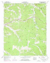
1951 Map of Negro Hollow
USGS Topo · Published 1977About this map
Waynesboro serves as the western anchor for this mid-century portrait of Wayne County, Tennessee, where the landscape is defined by an intricate network of hollows and ridges. The central Dick Cabin Ridge separates the watershed of Hurricane Creek from the eastern valleys drained by Forty-eight Creek. Of particular interest to genealogists and local historians are the numerous family-named burial grounds and houses of worship, including Copeland Cem, Walnut Grove Cem, and Mt Hope Ch. In the northeast, Liberty Hollow and Limekiln Hollow hint at early rural industry, while labels like Fourmile Board Hill and Tie Camp Hill provide insight into the timber and transit history of the area. Modern infrastructure begins to appear as well, noted by the Natchez Trace Parkway and the section of highway labeled Under Construction near Barlow Branch, marking the transition of the local road network during the 1950s.
Find a feature on this map
61 named features on this map. Tap any name to fly to it.
Don’t see what you’re looking for? This feature index may not catch every label — zoom into the map to look around manually.
Map Details
Editions of this 1951 Negro Hollow Map
3 editions found
Other maps of this area

1905 · Waynesboro
USGS Topo · 1:125,000

1936 · Riverside
USGS Topo · 1:24,000

1936 · Westpoint
USGS Topo · 1:24,000

1936 · Collinwood
USGS Topo · 1:24,000

1936 · Leatherwood
USGS Topo · 1:24,000

1936 · Negro Hollow
USGS Topo · 1:24,000

1936 · Three Churches
USGS Topo · 1:24,000

1936 · Waynesboro
USGS Topo · 1:24,000

1936 · Topsy
USGS Topo · 1:24,000

1936 · Ovilla
USGS Topo · 1:24,000