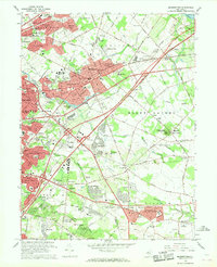
1966 Map of Moorestown
USGS Topo · Published 1968About this map
Moorestown and its neighboring boroughs appear during a period of significant suburban expansion in the mid-1960s. The landscape is a transition between the established residential cores of West Moorestown and Maple Shade and the developing subdivisions of Heritage Village and Kingston Estates. Major infrastructure like the New Jersey Turnpike and the Penn Central rail line facilitate this growth, cutting through former agricultural land. Notable institutional footprints are scattered throughout the area, including the Evergreen Home for the Aged, the Cistercian Monastery, and the USDA Research Lab. The map also preserves the locations of early local centers such as Colestown, Evesboro, and Cropwell, alongside local landmarks like the Moorestown Airport and the Drive-in Theater near Strawbridge Lake.
Find a feature on this map
99 named features on this map. Tap any name to fly to it.
Don’t see what you’re looking for? This feature index may not catch every label — zoom into the map to look around manually.
Map Details
Editions of this 1966 Moorestown Map
Other maps of this area

1888 · Mount Holly
USGS Topo · 1:62,500

1890 · Burlington
USGS Topo · 1:62,500

1891 · Philadelphia
USGS Topo · 1:62,500

1893 · Germantown
USGS Topo · 1:62,500

1893 · Burlington
USGS Topo · 1:62,500

1894 · Mount Holly
USGS Topo · 1:62,500

1894 · Philadelphia
USGS Topo · 1:62,500

1894 · Germantown
USGS Topo · 1:62,500

1896 · Germantown
USGS Topo · 1:62,500

1896 · Philadelphia
USGS Topo · 1:62,500
Featured Places
- Cherry Hill Township, NJ
- Mount Laurel Township, NJ
- Willingboro Township, NJ
- Moorestown Township, NJ
- Maple Shade Township, NJ