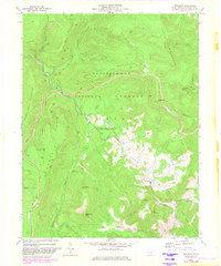
1977 Map of Woodrow
USGS Topo · Published 1982About this map
Woodrow sits at the base of the high elevations where the Gauley River and Williams River originate, anchoring a landscape defined by the heavy timber and rugged topography of the Monongahela National Forest. In the late 1970s, this area of Pocahontas County balanced conservation with industry, evidenced by active Strip Mines and a Strip Mine located near Yew Mountain and Sugar Creek Mountain. The map shows a region of transition as a Scenic Highway is noted as Under Construction, signaling a shift toward recreational access for the Handley Public Hunting and Fishing Area. Local history is preserved in small details like the Cem near the primary settlement and various family-named summits such as Big Spruce Knob and Little Spruce Knob. Waterways like Stony Creek and Tea Creek provide the drainage for the expansive Little Levels plateau, creating a complex network of runs and forks across the high Allegheny front.
Find a feature on this map
39 named features on this map. Tap any name to fly to it.
Don’t see what you’re looking for? This feature index may not catch every label — zoom into the map to look around manually.
Map Details
Editions of this 1977 Woodrow Map
2 editions found
Other maps of this area

1891 · Huntersville
USGS Topo · 1:125,000

1894 · Huntersville
USGS Topo · 1:125,000

1915 · Webster Springs
USGS Topo · 1:48,000

1918 · Webster Springs
USGS Topo · 1:62,500

1923 · Lobelia
USGS Topo · 1:48,000

1923 · Marlinton
USGS Topo · 1:48,000

1923 · Mingo
USGS Topo · 1:48,000

1925 · Mingo
USGS Topo · 1:62,500

1925 · Marlinton
USGS Topo · 1:62,500

1925 · Lobelia
USGS Topo · 1:62,500