
1996 Map of Percy Peaks
USGS Topo · Published 2000About this map
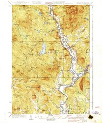
The Nash Stream Forest dominates this northern New Hampshire landscape, centered on the dramatic granite elevations of Percy Peaks. Revised in the mid-1990s, the map illustrates a region defined by heavy timber management and conservation, where logging infrastructure like Main Road and Jimmy Cole Brook Road snakes through the valleys of Nash Stream. To the south, the settlement at Percy sits along the Ammonoosuc River, serving as a historic point of access for the surrounding highlands. Notable landmarks including Jimmy Cole Ledge and Potters Ledge provide vertical relief above Christine Lake, while more remote waters such as Nash Bog Pond and Long Mountain Pond are sequestered in the high basins. The survey captures the complex boundary between the town of Stark and Northumberland, reflecting the area's transition from active resource extraction toward protected forest lands.
Find a feature on this map
43 named features on this map. Tap any name to fly to it.
Don’t see what you’re looking for? This feature index may not catch every label — zoom into the map to look around manually.
Map Details
Editions of this 1996 Percy Peaks Map
This is the sole edition of this map. No revisions or reprints were ever made.
Other maps of this area

1920 · Guildhall
USGS Topo · 1:62,500

1929 · Averill
USGS Topo · 1:62,500

1930 · Percy
USGS Topo · 1:62,500

1930 · Dixville
USGS Topo · 1:62,500

1931 · Guildhall
USGS Topo · 1:48,000

1933 · Guildhall
USGS Topo · 1:48,000

1933 · Dixville
USGS Topo · 1:62,500

1934 · Percy
USGS Topo · 1:62,500

1934 · Dixville
USGS Topo · 1:62,500
1937 · Guildhall
USGS Topo · 1:62,500