
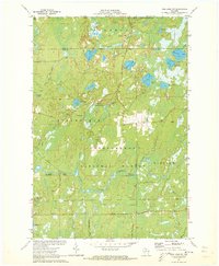
1971 Map of Pike Lake NW
USGS Topo · Published 1991About this map
The South Fork Flambeau River carves through the heart of the Chequamegon National Forest in this early 1970s survey. The landscape is defined by its complex glacial hydrology, featuring a dense network of water bodies such as Island Lake, Newman Lake, and Patterson Lake. Notable river features include Little Cedar Rapids and Cedar Rapids, while the presence of the Smith Rapids Campground indicates the area's established role for recreation during this era.
Find a feature on this map
41 named features on this map. Tap any name to fly to it.
Don’t see what you’re looking for? This feature index may not catch every label — zoom into the map to look around manually.
Map Details
Editions of this 1971 Pike Lake NW Map
3 editions found
Historical Maps of Fifield Through Time
139 maps found

1941 Brantwood
Price County, WI

1941 Kennedy
Price County, WI

1941 Pike Lake
Price County, WI

1942 Pike Lake
Price County, WI

1943 Brantwood
Price County, WI

1945 Kennedy
Price County, WI

1950 Pike Lake
Price County, WI

1968 Park Falls NE
Price County, WI

1968 Park Falls SE
Price County, WI

1970 Butternut Lake
Price County, WI

1970 Jump River Fire Tower NE
Price County, WI

1970 Lugerville
Price County, WI

1970 Ogema NW
Price County, WI

1971 Lac Sault Dore
Price County, WI
1971 Pike Lake NW
Price County, WI

1971 Pike Lake
Price County, WI

1971 Pike Lake SE
Price County, WI

1971 Pike Lake SW
Price County, WI

1979 Big Briens Lake
Price County, WI

1979 Brantwood
Price County, WI

1979 Dover
Price County, WI

1979 Spirit
Price County, WI

1979 Timms Hill
Price County, WI

1980 Thunder Creek
Price County, WI

1984 Blockhouse Lake
Price County, WI

1984 Cranberry Lake
Price County, WI

1984 Gates Lake
Price County, WI

1984 Pennington
Price County, WI

1984 Priest Lake
Price County, WI

2005 Blockhouse Lake
Price County, WI

2005 Dover
Price County, WI

2005 Gates Lake
Price County, WI

2005 Jump River Fire Tower NE
Price County, WI

2005 Ogema NW
Price County, WI

2005 Pike Lake NW
Price County, WI

2005 Pike Lake
Price County, WI

2005 Pike Lake SE
Price County, WI

2005 Pike Lake SW
Price County, WI

2005 Thunder Creek
Price County, WI

2010 Big Briens Lake
Price County, WI

2010 Brantwood
Price County, WI

2010 Butternut Lake
Price County, WI

2010 Cranberry Lake
Price County, WI

2010 Lac Sault Dore
Price County, WI

2010 Lugerville
Price County, WI

2010 Pennington
Price County, WI

2010 Priest Lake
Price County, WI

2010 Spirit
Price County, WI

2010 Timms Hill
Price County, WI

2011 Blockhouse Lake
Price County, WI

2011 Dover
Price County, WI

2011 Gates Lake
Price County, WI

2011 Jump River Fire Tower NE
Price County, WI

2011 Ogema NW
Price County, WI

2011 Pike Lake NW
Price County, WI

2011 Pike Lake
Price County, WI

2011 Pike Lake SE
Price County, WI

2011 Pike Lake SW
Price County, WI

2011 Thunder Creek
Price County, WI

2013 Big Briens Lake
Price County, WI

2013 Blockhouse Lake
Price County, WI

2013 Brantwood
Price County, WI

2013 Butternut Lake
Price County, WI

2013 Cranberry Lake
Price County, WI

2013 Dover
Price County, WI

2013 Gates Lake
Price County, WI

2013 Jump River Fire Tower NE
Price County, WI

2013 Lac Sault Dore
Price County, WI

2013 Lugerville
Price County, WI

2013 Ogema NW
Price County, WI

2013 Pennington
Price County, WI

2013 Pike Lake NW
Price County, WI

2013 Pike Lake
Price County, WI

2013 Pike Lake SE
Price County, WI

2013 Pike Lake SW
Price County, WI

2013 Priest Lake
Price County, WI

2013 Spirit
Price County, WI

2013 Thunder Creek
Price County, WI

2013 Timms Hill
Price County, WI

2015 Big Briens Lake
Price County, WI

2015 Blockhouse Lake
Price County, WI

2015 Brantwood
Price County, WI

2015 Butternut Lake
Price County, WI

2015 Cranberry Lake
Price County, WI

2015 Dover
Price County, WI

2015 Gates Lake
Price County, WI

2015 Jump River Fire Tower NE
Price County, WI

2015 Lac Sault Dore
Price County, WI

2015 Lugerville
Price County, WI

2015 Ogema NW
Price County, WI

2015 Pennington
Price County, WI

2015 Pike Lake NW
Price County, WI

2015 Pike Lake
Price County, WI

2015 Pike Lake SE
Price County, WI

2015 Pike Lake SW
Price County, WI

2015 Priest Lake
Price County, WI

2015 Spirit
Price County, WI

2015 Thunder Creek
Price County, WI

2015 Timms Hill
Price County, WI

2018 Big Briens Lake
Price County, WI

2018 Blockhouse Lake
Price County, WI

2018 Brantwood
Price County, WI

2018 Butternut Lake
Price County, WI

2018 Cranberry Lake
Price County, WI

2018 Dover
Price County, WI

2018 Gates Lake
Price County, WI

2018 Jump River Fire Tower NE
Price County, WI

2018 Lac Sault Dore
Price County, WI

2018 Lugerville
Price County, WI

2018 Ogema NW
Price County, WI

2018 Pennington
Price County, WI

2018 Pike Lake NW
Price County, WI

2018 Pike Lake
Price County, WI

2018 Pike Lake SE
Price County, WI

2018 Pike Lake SW
Price County, WI

2018 Priest Lake
Price County, WI

2018 Spirit
Price County, WI

2018 Thunder Creek
Price County, WI

2018 Timms Hill
Price County, WI

2022 Big Briens Lake
Price County, WI

2022 Blockhouse Lake
Price County, WI

2022 Butternut Lake
Price County, WI

2022 Cranberry Lake
Price County, WI

2022 Dover
Price County, WI

2022 Jump River Fire Tower NE
Price County, WI

2022 Lac Sault Dore
Price County, WI

2022 Lugerville
Price County, WI

2022 Ogema NW
Price County, WI

2022 Pennington
Price County, WI

2022 Pike Lake NW
Price County, WI

2022 Pike Lake SW
Price County, WI

2022 Thunder Creek
Price County, WI

2022 Timms Hill
Price County, WI

2023 Brantwood
Price County, WI

2023 Gates Lake
Price County, WI

2023 Pike Lake
Price County, WI

2023 Pike Lake SE
Price County, WI

2023 Priest Lake
Price County, WI

2023 Spirit
Price County, WI