1997 Map of Robinson Mesa
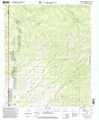
USGS Topo · Published 2000This historical map portrays the area of Robinson Mesa in 1997, primarily covering Greenlee County as well as portions of Graham County. Featuring a scale of 1:24000, this map provides a highly detailed snapshot of the terrain, roads, buildings, counties, and historical landmarks in the Robinson Mesa region at the time. Published in 2000, it is one of 2 known editions of this map due to revisions or reprints.
Map Details
Editions of this 1997 Robinson Mesa Map
2 editions found

Historical Maps of Graham County Through Time
58 maps found

1958 Hannagan Meadow
Greenlee County, AZ

1959 York Valley
Greenlee County, AZ

1961 Blue
Greenlee County, AZ

1962 Big Lue Mts
Greenlee County, AZ

1967 Alma Mesa
Greenlee County, AZ

1967 Bee Canyon
Greenlee County, AZ

1967 Dutch Blue Creek
Greenlee County, AZ

1967 Fritz Canyon
Greenlee County, AZ

1967 Maple Peak
Greenlee County, AZ

1967 Pipestem Mountain
Greenlee County, AZ

1967 Robinson Mesa
Greenlee County, AZ

1967 Rose Peak
Greenlee County, AZ

1986 Guthrie
Greenlee County, AZ

1986 Hot Well
Greenlee County, AZ

1986 Round Mountain
Greenlee County, AZ

1986 Sheldon
Greenlee County, AZ

1986 Whitlock Peak
Greenlee County, AZ

1989 Big Lue Mountains
Greenlee County, AZ

1989 Copperplate Gulch
Greenlee County, AZ

1989 Coronado Mountain
Greenlee County, AZ

1989 Dix Creek
Greenlee County, AZ

1989 Mitchell Peak
Greenlee County, AZ

1989 Rattlesnake Spring
Greenlee County, AZ

1991 Baldy Bill Point
Greenlee County, AZ

1991 Bear Mountain
Greenlee County, AZ

1991 Beaverhead
Greenlee County, AZ

1991 Blue
Greenlee County, AZ

1991 Hannagan Meadow
Greenlee County, AZ

1991 Hoodoo Knoll
Greenlee County, AZ

1991 Maness Peak
Greenlee County, AZ

1991 Strayhorse
Greenlee County, AZ

1997 Alma Mesa
Greenlee County, AZ

1997 Baldy Bill Point
Greenlee County, AZ

1997 Bear Mountain
Greenlee County, AZ

1997 Beaverhead
Greenlee County, AZ

1997 Bee Canyon
Greenlee County, AZ

1997 Big Lue Mountains
Greenlee County, AZ

1997 Blue
Greenlee County, AZ

1997 Copperplate Gulch
Greenlee County, AZ

1997 Coronado Mountain
Greenlee County, AZ

1997 Dix Creek
Greenlee County, AZ

1997 Dutch Blue Creek
Greenlee County, AZ

1997 Fritz Canyon
Greenlee County, AZ

1997 Hannagan Meadow
Greenlee County, AZ

1997 Hoodoo Knoll
Greenlee County, AZ

1997 Maness Peak
Greenlee County, AZ

1997 Maple Peak
Greenlee County, AZ

1997 Mitchell Peak
Greenlee County, AZ

1997 Pipestem Mountain
Greenlee County, AZ

1997 Rattlesnake Spring
Greenlee County, AZ
1997 Robinson Mesa
Greenlee County, AZ

1997 Rose Peak
Greenlee County, AZ

1997 Strayhorse
Greenlee County, AZ

2005 Alma Mesa
Greenlee County, AZ

2005 Big Lue Mountains
Greenlee County, AZ

2005 Blue
Greenlee County, AZ

2005 Maness Peak
Greenlee County, AZ

2005 Maple Peak
Greenlee County, AZ