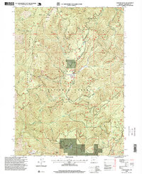
1996 Map of Chrome Ridge
USGS Topo · Published 1999About this map
Mining operations and timber management define the landscape within the Siskiyou National Forest during the late twentieth century. High-elevation extraction points like the Barr Mine and Elkhorn Mine sit alongside numerous prospects and quarries, indicating a continued interest in the mineral deposits that gave Chrome Mountain its name. The terrain is marked by a complex network of forest roads and trails that traverse significant landforms such as Chrome Ridge and Lone Tree Ridge, connecting remote locations like the Chrome Campsite and the Sam Brown landmark. Water drainage patterns are clearly established by the deep valleys of Onion Creek and Secret Valley Creek, while the Eighth Standard Parallel South provides a formal surveying boundary across this Josephine County interior. The concentration of mining sites around Freeland Mountain and Swede Basin suggests a geography shaped by historic prospecting that persisted into this 1990s revision.
Find a feature on this map
36 named features on this map. Tap any name to fly to it.
Don’t see what you’re looking for? This feature index may not catch every label — zoom into the map to look around manually.
Map Details
Editions of this 1996 Chrome Ridge Map
This is the sole edition of this map. No revisions or reprints were ever made.
Other maps of this area

1917 · Kerby
USGS Topo · 1:125,000

1918 · Kerby
USGS Topo · 1:125,000

1945 · Kerby
USGS Topo · 1:125,000

1946 · Galice
USGS Topo · 1:62,500

1948 · Galice
USGS Topo · 1:62,500

1954 · Marial
USGS Topo · 1:62,500

1954 · Selma
USGS Topo · 1:62,500

1954 · Pearsoll Peak
USGS Topo · 1:62,500

1955 · Medford
USGS Topo · 1:250,000

1957 · Medford
USGS Topo · 1:250,000