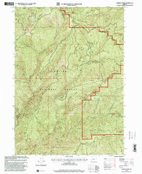
1998 Map of Hobson Horn
USGS Topo · Published 2001About this map
The Siskiyou National Forest dominates this late-twentieth-century landscape, capturing the complex drainage systems of the Southern Oregon coast range. The map reveals a wild network of waterways, where Shasta Costa Creek and Indigo Creek carve through steep topography defined by Shasta Ridge and Brandy Peak. A notable modern insertion into this remote terrain is the Hobson Horn Communication Facility, signaling the technological infrastructure required for fire management and regional communications in the 1990s. The presence of the Hellgate Back Country Byway highlights the area's transition toward recreational management, providing access to landmarks like Montana Spring. This document serves as a detailed record of the borderlands between Curry and Josephine counties just before the turn of the millennium.
Find a feature on this map
27 named features on this map. Tap any name to fly to it.
Don’t see what you’re looking for? This feature index may not catch every label — zoom into the map to look around manually.
Map Details
Editions of this 1998 Hobson Horn Map
This is the sole edition of this map. No revisions or reprints were ever made.
Other maps of this area

1917 · Kerby
USGS Topo · 1:125,000

1918 · Kerby
USGS Topo · 1:125,000

1945 · Kerby
USGS Topo · 1:125,000

1946 · Galice
USGS Topo · 1:62,500

1948 · Galice
USGS Topo · 1:62,500

1954 · Marial
USGS Topo · 1:62,500

1954 · Selma
USGS Topo · 1:62,500

1954 · Pearsoll Peak
USGS Topo · 1:62,500

1955 · Medford
USGS Topo · 1:250,000

1957 · Medford
USGS Topo · 1:250,000