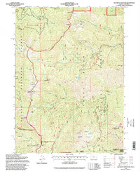
1996 Map of Grayback Mountain
USGS Topo · Published 1998About this map
Grayback Mountain and Big Sugarloaf Peak dominate the high-elevation terrain along the boundary of the Siskiyou National Forest and Rogue River National Forest. This 1990s record captures a landscape defined by rugged peaks and the deep drainages of Grayback Creek, Sturgis Fork, and Sucker Creek. The map documents evidence of historical human activity in these remote areas, from the mining history at Mountain View Mine and Arnold Mine to the remnants of the Browntown settlement. Shelters and habitations like Krause Cabin, Deoman Cabin, and the Sucker Creek Shelter are scattered throughout the forests, often situated near vital water sources like Miller Lake or Hinkle Lake. The inclusion of the Red Buttes Wilderness highlights the region's protected character along the Oregon-California state line, where high-country meadows like Elkhorn Prairie break the timberline.
Find a feature on this map
65 named features on this map. Tap any name to fly to it.
Don’t see what you’re looking for? This feature index may not catch every label — zoom into the map to look around manually.
Map Details
Editions of this 1996 Grayback Mountain Map
This is the sole edition of this map. No revisions or reprints were ever made.
Other maps of this area

1908 · Grants Pass
USGS Topo · 1:125,000

1914 · Seiad
USGS Topo · 1:125,000

1922 · Seiad
USGS Topo · 1:125,000

1948 · Weed
USGS Topo · 1:250,000

1950 · Weed
USGS Topo · 1:250,000

1954 · Oregon Caves
USGS Topo · 1:62,500

1954 · Ruch
USGS Topo · 1:62,500

1955 · Seiad Valley
USGS Topo · 1:62,500

1955 · Medford
USGS Topo · 1:250,000

1956 · Happy Camp
USGS Topo · 1:62,500