
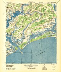
1944 Map of Wadmelaw Island
USGS Topo · Published 1944About this map
The salt marshes and tidal estuaries of the South Carolina Lowcountry define this landscape as it appeared just before the mid-century, surveyed originally in 1918. Wadmalaw Island and Johns Island dominate the center of the sheet, connected by a network of waterways including Bohicket Creek and the Wadmalaw River. Rural life is marked by numerous small educational and spiritual centers such as Sandhill School, Jerusalem School, and Enterprise Church, alongside industrial footprints like the Crate Mill near the riverfront.
Find a feature on this map
74 named features on this map. Tap any name to fly to it.
Don’t see what you’re looking for? This feature index may not catch every label — zoom into the map to look around manually.
Map Details
Editions of this 1944 Wadmelaw Island Map
2 editions found
Other maps of this area

1918 · Kiawah Island
USGS Topo · 1:21,120

1918 · Cottageville
USGS Topo · 1:62,500

1919 · Johns Island
USGS Topo · 1:21,120

1919 · Edisto Island
USGS Topo · 1:62,500

1919 · Wadmelaw Island
USGS Topo · 1:62,500

1919 · Charleston
USGS Topo · 1:21,120

1919 · James Island
USGS Topo · 1:21,120

1919 · Legareville
USGS Topo · 1:21,120

1920 · St. Helena Sound
USGS Topo · 1:62,500

1920 · Ravenels
USGS Topo · 1:62,500