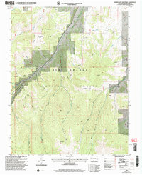
2001 Map of Horseshoe Mountain
USGS Topo · Published 2005About this map
Rio Grande National Forest dominates this high-country landscape, where complex drainage networks carve through the southern Colorado peaks. Steep-walled canyons such as Barriclause Canyon and Munger Canyon drop toward the valley floors, defining the geography of the high forest. A Gaging Station on Los Pinos Creek indicates the importance of water management in this arid alpine environment, while the presence of a Pipeline and numerous 4WD tracks suggest a landscape utilized for modern utility and resource access alongside recreation. Extensive trail systems, including the Bennett Trail and Frisco Trail, provide access to landmarks like Horseshoe Mountain and the high basin of Horseshoe Park. To the south, the terrain rises toward Poison Mountain, overlooking the headwaters of Raton Creek and the intricate forks of San Francisco Creek, illustrating the remote and hydrological character of this portion of the Rio Grande basin.
Find a feature on this map
34 named features on this map. Tap any name to fly to it.
Don’t see what you’re looking for? This feature index may not catch every label — zoom into the map to look around manually.
Map Details
Editions of this 2001 Horseshoe Mountain Map
This is the sole edition of this map. No revisions or reprints were ever made.
Other maps of this area

1913 · Summitville
USGS Topo · 1:125,000

1914 · Creede
USGS Topo · 1:125,000

1915 · Summitville
USGS Topo · 1:125,000

1915 · Del Norte
USGS Topo · 1:125,000

1916 · Creede
USGS Topo · 1:125,000

1917 · Del Norte
USGS Topo · 1:125,000

1922 · Conejos
USGS Topo · 1:125,000

1945 · Durango
USGS Topo · 1:250,000

1953 · Durango
USGS Topo · 1:250,000

1954 · Durango
USGS Topo · 1:250,000