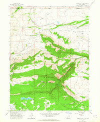
1963 Map of Jessen Butte
USGS Topo · Published 1965About this map
Ashley National Forest dominates this mid-century survey, revealing a landscape defined by water management and high-altitude basins along the border of Utah and Wyoming. The northern sections show the agricultural infrastructure of the Lucerne Valley, where the Lucerne Valley Canal and various unnamed canals distribute water through the arid terrain. To the south, the topography rises sharply toward the namesake Jessen Butte and into the timbered reaches of the national forest. Public recreation and land use are evident in the placement of the Palisade Campground and the naming of high-country meadows like Sheep Creek Park and Half Moon Park. Geologic and topographic features such as Conner Basin and Windy Ridge highlight the complex drainage patterns of Sheep Creek and its many tributaries, while a lone Landing Strip and various jeep trails indicate the era's methods of backcountry access.
Find a feature on this map
35 named features on this map. Tap any name to fly to it.
Don’t see what you’re looking for? This feature index may not catch every label — zoom into the map to look around manually.
Map Details
Editions of this 1963 Jessen Butte Map
2 editions found
Other maps of this area

1885 · Ashley
USGS Topo · 1:250,000

1906 · Marsh Peak
USGS Topo · 1:125,000

1908 · Marsh Peak
USGS Topo · 1:125,000

1954 · Vernal
USGS Topo · 1:250,000

1954 · Rock Springs
USGS Topo · 1:250,000

1958 · Vernal
USGS Topo · 1:250,000

1958 · Rock Springs
USGS Topo · 1:250,000

1960 · Vernal
USGS Topo · 1:250,000

1962 · Rock Springs
USGS Topo · 1:250,000
1963 · Whiterocks Lake
USGS Topo · 1:24,000