
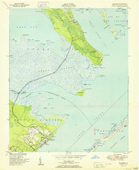
1950 Map of Point Of Marsh
USGS Topo · Published 1950About this map
Pamlico Sound and the Neuse River converge at the Point of Marsh, a marshy peninsula that dominates the entrance to these North Carolina waters. The landscape is defined by intricate tidal fingers and expansive flats, including Piney Island and the northern reaches of Cedar Island. This post-war survey illustrates a coastal environment governed by the rhythm of the tides, where small protected pockets like Henry Hills Harbor and Peters Cove offer respite from the open sound. Navigation is supported by established markers such as Point of Marsh Lt and Cedar Island Bay Lt. The map reveals a complex network of internal waterways like The Narrows and Meredith Bend, which separate the islands from the mainland of Hunting Quarters. This area, primarily salt marsh and wetland, showcases the shifting shorelines of Rattan Bay and South Bay before modern coastal alterations.
Find a feature on this map
44 named features on this map. Tap any name to fly to it.
Don’t see what you’re looking for? This feature index may not catch every label — zoom into the map to look around manually.
Map Details
Editions of this 1950 Point Of Marsh Map
This is the sole edition of this map. No revisions or reprints were ever made.
Other maps of this area

1948 · North Bay
USGS Topo · 1:24,000

1949 · Atlantic
USGS Topo · 1:24,000

1949 · Point Of Marsh
USGS Topo · 1:24,000

1949 · Long Bay
USGS Topo · 1:24,000

1949 · South River
USGS Topo · 1:24,000

1950 · Long Bay
USGS Topo · 1:24,000

1950 · South River
USGS Topo · 1:24,000

1950 · North Bay
USGS Topo · 1:24,000

1950 · Jones Bay
USGS Topo · 1:24,000
1951 · Atlantic
USGS Topo · 1:24,000