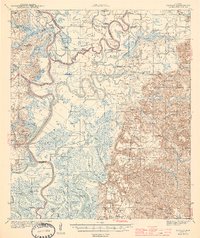
1944 Map of Tensaw
USGS Topo · Published 1944This historical map portrays the area of Tensaw in 1944, primarily covering Baldwin County as well as portions of Washington County, Mobile County, and Clarke County. Featuring a scale of 1:62500, this map provides a highly detailed snapshot of the terrain, roads, buildings, counties, and historical landmarks in the Tensaw region at the time. Published in 1944, it is one of 3 known editions of this map due to revisions or reprints.
Find a feature on this map
103 named features on this map. Tap any name to fly to it.
Don’t see what you’re looking for? This feature index may not catch every label — zoom into the map to look around manually.
Map Details
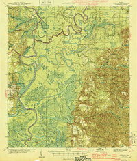
Editions of this 1944 Tensaw Map
3 editions found
Historical Maps of Mount Vernon Through Time
62 maps found

1941 Blakeley
Baldwin County, AL

1941 Weeks Bay
Baldwin County, AL

1942 Blakeley
Baldwin County, AL

1942 Dyas
Baldwin County, AL

1942 Hurricane
Baldwin County, AL

1943 Blakeley
Baldwin County, AL

1943 Hurricane
Baldwin County, AL

1943 Tensaw
Baldwin County, AL

1943 Weeks Bay
Baldwin County, AL

1944 Dyas
Baldwin County, AL

1944 Miflin
Baldwin County, AL

1944 Muscogee
Baldwin County, AL

1944 Tensaw
Baldwin County, AL

1953 Bridgehead
Baldwin County, AL

1953 Hurricane
Baldwin County, AL

1958 Fort Morgan
Baldwin County, AL

1978 Dogwood Creek
Baldwin County, AL

1978 Dyas
Baldwin County, AL

1978 Gateswood
Baldwin County, AL

1978 Seminole
Baldwin County, AL

1980 Bay Minette North
Baldwin County, AL

1980 Bay Minette South
Baldwin County, AL

1980 Bon Secour Bay
Baldwin County, AL

1980 Elsanor
Baldwin County, AL

1980 Little Point Clear
Baldwin County, AL

1980 Pine Beach
Baldwin County, AL

1980 St. Andrews Bay
Baldwin County, AL

1980 Steelwood Lake
Baldwin County, AL

1980 The Basin
Baldwin County, AL

1983 Bilbo Island
Baldwin County, AL

1983 Blacksher
Baldwin County, AL

1983 Stiggings Lake
Baldwin County, AL

1983 Tensaw
Baldwin County, AL

1983 Vaughn
Baldwin County, AL

1986 Bay Minette North
Baldwin County, AL

1994 Dogwood Creek
Baldwin County, AL

1994 Dyas
Baldwin County, AL

1994 Gateswood
Baldwin County, AL

1997 Hurricane
Baldwin County, AL

2003 Dyas
Baldwin County, AL

2024 Bay Minette North
Baldwin County, AL

2024 Bay Minette South
Baldwin County, AL

2024 Bilbo Island
Baldwin County, AL

2024 Blacksher
Baldwin County, AL

2024 Bon Secour Bay
Baldwin County, AL

2024 Bridgehead
Baldwin County, AL

2024 Dogwood Creek
Baldwin County, AL

2024 Dyas
Baldwin County, AL

2024 Elsanor
Baldwin County, AL

2024 Gateswood
Baldwin County, AL

2024 Hurricane
Baldwin County, AL

2024 Little Point Clear
Baldwin County, AL

2024 Seminole
Baldwin County, AL

2024 Steelwood Lake
Baldwin County, AL

2024 Stiggins Lake
Baldwin County, AL

2024 Tensaw
Baldwin County, AL

2024 The Basin
Baldwin County, AL

2024 Vaughn
Baldwin County, AL

2025 Fort Morgan
Baldwin County, AL

2025 Gulf Shores OE S
Baldwin County, AL

2025 Pine Beach
Baldwin County, AL

2025 Saint Andrews Bay
Baldwin County, AL