1957 Map of West of Johnson Bayou
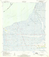
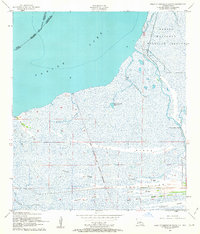
USGS Topo · Published 1958This historical map portrays the area of West of Johnson Bayou in 1957, primarily covering Cameron Parish as well as portions of Cameron County and Texas. Featuring a scale of 1:24000, this map provides a highly detailed snapshot of the terrain, roads, buildings, counties, and historical landmarks in the West of Johnson Bayou region at the time. Published in 1958, it is one of 3 known editions of this map due to revisions or reprints.
Find a feature on this map
23 named features on this map. Tap any name to fly to it.
Don’t see what you’re looking for? This feature index may not catch every label — zoom into the map to look around manually.
Map Details
Editions of this 1957 West of Johnson Bayou Map
3 editions found
Historical Maps of Jefferson County Through Time
80 maps found

1932 Constance Bayou NW
Cameron Parish, LA

1932 Constance Bayou SW
Cameron Parish, LA

1932 Port Arthur NE
Cameron Parish, LA

1934 Boudreaux Lake
Cameron Parish, LA

1934 Browns Lake
Cameron Parish, LA

1934 Catfish Lake
Cameron Parish, LA

1934 Five Lakes
Cameron Parish, LA

1934 Grand Bayou
Cameron Parish, LA

1934 Greens Bayou
Cameron Parish, LA

1934 Holly Beach
Cameron Parish, LA

1934 Johnsons Bayou
Cameron Parish, LA

1934 Lake Misere
Cameron Parish, LA

1934 Latania Lake
Cameron Parish, LA

1934 Peveto Beach
Cameron Parish, LA

1934 Sweet Lake
Cameron Parish, LA

1935 Bay Labauve
Cameron Parish, LA

1935 Boudreaux Lake
Cameron Parish, LA

1935 Browns Lake
Cameron Parish, LA

1935 Catfish Lake
Cameron Parish, LA

1935 Five Lakes
Cameron Parish, LA

1935 Grand Bayou
Cameron Parish, LA

1935 Grand Chenier
Cameron Parish, LA

1935 Greens Bayou
Cameron Parish, LA

1935 Holly Beach
Cameron Parish, LA

1935 Johnsons Bayou
Cameron Parish, LA

1935 Lake Misere
Cameron Parish, LA

1935 Latania Lake
Cameron Parish, LA

1935 Peveto Beach
Cameron Parish, LA

1935 Sweet Lake
Cameron Parish, LA

1943 West of Johnson Bayou
Cameron Parish, LA

1946 Hog Bayou NE
Cameron Parish, LA

1946 Hog Bayou NW
Cameron Parish, LA

1946 Phoenix Lake
Cameron Parish, LA

1946 Port Arthur NE
Cameron Parish, LA

1946 Port Arthur SE
Cameron Parish, LA

1949 Hog Bayou NE
Cameron Parish, LA

1949 Hog Bayou NW
Cameron Parish, LA

1954 Constance Bayou NW
Cameron Parish, LA

1954 Constance Bayou SW
Cameron Parish, LA

1954 Grand Lake East NW
Cameron Parish, LA

1954 Grand Lake East SW
Cameron Parish, LA

1954 Phoenix Lake
Cameron Parish, LA

1955 Constance Bayou
Cameron Parish, LA

1955 Grand Lake East
Cameron Parish, LA

1955 Grand Lake West
Cameron Parish, LA

1955 Hog Bayou
Cameron Parish, LA

1955 Johnsons Bayou
Cameron Parish, LA

1955 Sweet Lake
Cameron Parish, LA

1957 West of Johnson Bayou
Cameron Parish, LA

1975 Grand Bayou
Cameron Parish, LA

1975 Holly Beach
Cameron Parish, LA

1975 Johnsons Bayou
Cameron Parish, LA

1975 Peveto Beach
Cameron Parish, LA

1979 Big Constance Lake
Cameron Parish, LA

1979 Collicon Lake
Cameron Parish, LA

1979 Cow Island
Cameron Parish, LA

1979 Deep Lake
Cameron Parish, LA

1979 Hog Bayou
Cameron Parish, LA

1979 Mallard Bay
Cameron Parish, LA

1980 Catfish Lake
Cameron Parish, LA

1980 Grand Chenier
Cameron Parish, LA

1980 Lake Misere
Cameron Parish, LA

1980 Latania Lake
Cameron Parish, LA

1982 Boudreaux Lake
Cameron Parish, LA

1982 Browns Lake
Cameron Parish, LA

1982 Creole
Cameron Parish, LA

1982 F-R Ranch
Cameron Parish, LA

1982 Grand Bayou
Cameron Parish, LA

1982 Greens Bayou
Cameron Parish, LA

1982 Hackberry Beach
Cameron Parish, LA

1982 Holly Beach
Cameron Parish, LA

1982 Johnsons Bayou
Cameron Parish, LA

1982 Peveto Beach
Cameron Parish, LA

1982 Smith Bayou
Cameron Parish, LA

1982 Sweet Lake
Cameron Parish, LA

1993 West of Johnson Bayou
Cameron Parish, LA

1998 Catfish Lake
Cameron Parish, LA

1998 Grand Bayou
Cameron Parish, LA

1998 Holly Beach
Cameron Parish, LA

1998 Peveto Beach
Cameron Parish, LA