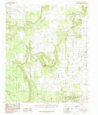
1984 Map of Graford West
USGS Topo · Published 1987About this map
Mc Clure Mountain dominates the central landscape of this North Texas survey, where the winding drainage systems of Keechi Creek and Dark Valley Creek carve through the limestone terrain of Palo Pinto County. The settlement of Graford serves as the primary eastern hub, situated near the intersection of several local routes including Highway 337. To the south, the Brazos River creates a prominent oxbow at B C Harris Bend, a feature that has long dictated the local agricultural and property boundaries in the river valley. The map documents a transition from the elevated plateaus of Rocky Prairie down through Scott Canyon. Notable for its hydrological detail, the sheet traces numerous seasonal waterways such as Pecan Branch and Frog Branch, alongside evidence of local industry at a Gravel Pit near the eastern edge.
Find a feature on this map
20 named features on this map. Tap any name to fly to it.
Don’t see what you’re looking for? This feature index may not catch every label — zoom into the map to look around manually.
Map Details
Editions of this 1984 Graford West Map
2 editions found
Other maps of this area

1891 · Palo Pinto
USGS Topo · 1:125,000

1918 · Palo Pinto
USGS Topo · 1:125,000

1924 · Palo Pinto 2-b
USGS Topo · 1:48,000

1924 · Palo Pinto 2-a
USGS Topo · 1:48,000

1924 · Palo Pinto 1-b
USGS Topo · 1:48,000

1924 · Palo Pinto 2-c
USGS Topo · 1:48,000

1927 · Pickwick
USGS Topo · 1:62,500

1927 · Mineral Wells
USGS Topo · 1:62,500

1954 · Abilene
USGS Topo · 1:250,000

1954 · Wichita Falls
USGS Topo · 1:250,000