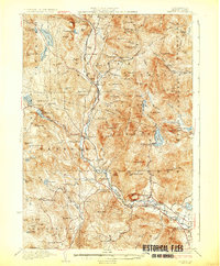
1932 Map of Rumney
USGS Topo · Published 1932About this map
White Mountain National Forest dominates this topographic landscape, where the Baker River carves a deep valley through the high peaks of Grafton County. In the early 1930s, the region’s economy and transport were anchored by the Boston and Maine RR, which served a series of small riverside communities including Wentworth, West Rumney PO Swainboro Sta, and Rumney Depot.
Find a feature on this map
106 named features on this map. Tap any name to fly to it.
Don’t see what you’re looking for? This feature index may not catch every label — zoom into the map to look around manually.
Map Details
Editions of this 1932 Rumney Map
5 editions found

Other maps of this area

1925 · Holderness
USGS Topo · 1:62,500

1927 · Holderness
USGS Topo · 1:62,500

1927 · Cardigan
USGS Topo · 1:62,500

1927 · Mascoma
USGS Topo · 1:62,500

1928 · Plymouth
USGS Topo · 1:62,500

1928 · Rumney
USGS Topo · 1:62,500

1929 · Moosilauke
USGS Topo · 1:62,500

1929 · Franconia
USGS Topo · 1:62,500

1930 · Cardigan
USGS Topo · 1:62,500

1931 · Mt. Cube
USGS Topo · 1:62,500