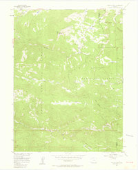
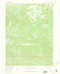
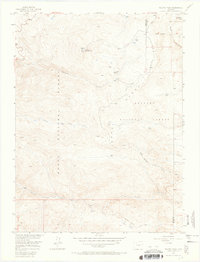
1956 Map of Walton Peak
USGS Topo · Published 1958This historical map portrays the area of Walton Peak in 1956, primarily covering Routt County as well as portions of Grand County. Featuring a scale of 1:24000, this map provides a highly detailed snapshot of the terrain, roads, buildings, counties, and historical landmarks in the Walton Peak region at the time. Published in 1958, it is one of 4 known editions of this map due to revisions or reprints.
Find a feature on this map
16 named features on this map. Tap any name to fly to it.
Don’t see what you’re looking for? This feature index may not catch every label — zoom into the map to look around manually.
Map Details
Editions of this 1956 Walton Peak Map
4 editions found
Historical Maps of Routt County Through Time
69 maps found

1911 Hahns Peak
Routt County, CO

1913 Hahns Peak
Routt County, CO

1916 Daton Peak
Routt County, CO

1920 Daton Peak
Routt County, CO

1923 Pilot Knob
Routt County, CO

1924 Mount Harris
Routt County, CO

1925 Pilot Knob
Routt County, CO

1926 Mount Harris
Routt County, CO

1955 Mount Ethel
Routt County, CO

1955 Mount Zirkel
Routt County, CO

1956 Mount Werner
Routt County, CO

1956 Rabbit Ears Peak
Routt County, CO

1956 Walton Peak
Routt County, CO

1962 Bears Ears Peaks
Routt County, CO

1962 Clark
Routt County, CO

1962 Elkhorn Mountain
Routt County, CO

1962 Farwell Mountain
Routt County, CO

1962 Floyd Peak
Routt County, CO

1962 Hahns Peak
Routt County, CO

1962 Mad Creek
Routt County, CO

1962 Meaden Peak
Routt County, CO

1962 Rocky Peak
Routt County, CO

1962 Shield Mountain
Routt County, CO

1962 Tumble Mountain
Routt County, CO

1969 Blacktail Mountain
Routt County, CO

1969 Cow Creek
Routt County, CO

1971 Dunckley
Routt County, CO

1971 Hayden Gulch
Routt County, CO

1971 Hooker Mountain
Routt County, CO

1971 Milner
Routt County, CO

1971 Mount Harris
Routt County, CO

1971 Pilot Knob
Routt County, CO

1971 Quaker Mountain
Routt County, CO

1971 Rattlesnake Butte
Routt County, CO

1971 Rock Spring Gulch
Routt County, CO

1971 Wolf Mountain
Routt County, CO

1972 Blue Hill
Routt County, CO

1972 Burns North
Routt County, CO

1972 Green Ridge
Routt County, CO

1972 Mc Coy
Routt County, CO

1972 Toponas
Routt County, CO

1972 Trapper
Routt County, CO

1980 Gore Mountain
Routt County, CO

1980 Lynx Pass
Routt County, CO

2000 Bears Ears Peaks
Routt County, CO

2000 Blacktail Mountain
Routt County, CO

2000 Clark
Routt County, CO

2000 Dunckley
Routt County, CO

2000 Elkhorn Mountain
Routt County, CO

2000 Farwell Mountain
Routt County, CO

2000 Floyd Peak
Routt County, CO

2000 Gore Mountain
Routt County, CO

2000 Green Ridge
Routt County, CO

2000 Hahns Peak
Routt County, CO

2000 Hayden Gulch
Routt County, CO

2000 Lynx Pass
Routt County, CO

2000 Mad Creek
Routt County, CO

2000 Meaden Peak
Routt County, CO

2000 Mount Ethel
Routt County, CO

2000 Mount Werner
Routt County, CO

2000 Mount Zirkel
Routt County, CO

2000 Pilot Knob
Routt County, CO

2000 Quaker Mountain
Routt County, CO

2000 Rattlesnake Butte
Routt County, CO

2000 Rocky Peak
Routt County, CO

2000 Shield Mountain
Routt County, CO

2000 Toponas
Routt County, CO

2000 Trapper
Routt County, CO

2000 Walton Peak
Routt County, CO