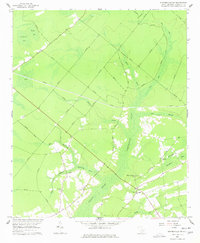
1958 Map of Summerville NW
USGS Topo · Published 1977About this map
Wassamasaw Swamp and the broad expanse of Cypress Swamp dominate this Berkeley County landscape, revealing a lowland environment defined by sluggish waterways and isolated upland ridges. In the late 1950s, the rural character of the region was anchored by community landmarks such as Wassamasaw Ch, Lebanon Ch, and St James Ch. The topography is marked by several elliptical depressions known as Carolina Bays, including Mosquito Bay, Caton Bay, and Ditch Bay, which disrupt the otherwise uniform drainage patterns of Partridge Creek and Rudd Branch. Surveyed just before significant modern development reached the area, the map preserves the alignment of local thoroughfares like Millpond Road and Calamus Pond Road as they navigate the wetlands. Notable higher ground is found at Long Ridge Bay, where Canaan Ch sits at the edge of the swampy bottomlands.
Find a feature on this map
20 named features on this map. Tap any name to fly to it.
Don’t see what you’re looking for? This feature index may not catch every label — zoom into the map to look around manually.
Map Details
Editions of this 1958 Summerville NW Map
3 editions found
Other maps of this area

1919 · Summerville
USGS Topo · 1:48,000

1919 · Ridgeville
USGS Topo · 1:48,000

1920 · Eutawville
USGS Topo · 1:48,000

1920 · Chicora
USGS Topo · 1:48,000

1920 · Ridgeville
USGS Topo · 1:62,500

1920 · Summerville
USGS Topo · 1:62,500

1921 · Chicora
USGS Topo · 1:62,500

1921 · Eutawville
USGS Topo · 1:62,500

1943 · Chicora
USGS Topo · 1:62,500

1943 · Ridgeville
USGS Topo · 1:62,500