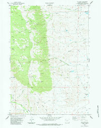
1984 Map of The Horn
USGS Topo · Published 1984About this map
The Horn dominates this Wyoming landscape, where high-altitude ridges give way to a complex network of canyons and water-management features. The map illustrates the region's reliance on water infrastructure for ranching and agriculture, noted by the Morgareidge Ditch, Canon Ditch, and several reservoirs including Willow Glen Reservoir and Lyle Reservoir. The presence of Dancehall and a remote Landing Strip suggests a pocket of social and logistical activity in an otherwise sparsely populated ranching territory.
Find a feature on this map
33 named features on this map. Tap any name to fly to it.
Don’t see what you’re looking for? This feature index may not catch every label — zoom into the map to look around manually.
Map Details
Editions of this 1984 The Horn Map
This is the sole edition of this map. No revisions or reprints were ever made.
Other maps of this area

1900 · Fort McKinney
USGS Topo · 1:125,000

1903 · Fort McKinney
USGS Topo · 1:125,000

1955 · Sheridan
USGS Topo · 1:250,000

1955 · Arminto
USGS Topo · 1:250,000

1958 · Sheridan
USGS Topo · 1:250,000

1958 · Arminto
USGS Topo · 1:250,000

1961 · Schlict Draw
USGS Topo · 1:24,000

1961 · Hibbard Draw
USGS Topo · 1:24,000

1962 · Sheridan
USGS Topo · 1:250,000

1962 · Arminto
USGS Topo · 1:250,000