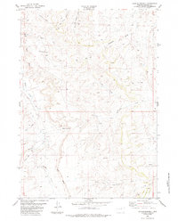
1984 Map of Hole-in-the-wall
USGS Topo · Published 1984About this map
Hole-In-The-Wall and the dramatic escarpment of the Red Wall define this landscape in Johnson County, Wyoming. This topographic record, compiled from 1970s aerial photography, captures a remote ranching environment characterized by extensive water management and livestock infrastructure. Numerous corrals, springs, and shearing pens are scattered across the draws, indicating the area's primary sheep and cattle operations. The map details a complex network of drainage systems including Buffalo Creek, Murphy Creek, and Posey Creek, which carve through the high plains terrain. Local landmarks such as Bar C Gap and Peterson Draw provide navigational points along the various jeep trails that navigate the breaks. The presence of a Drill Hole and Tank further illustrates the practical utility of the land for range management and resource exploration during the late twentieth century.
Find a feature on this map
22 named features on this map. Tap any name to fly to it.
Don’t see what you’re looking for? This feature index may not catch every label — zoom into the map to look around manually.
Map Details
Editions of this 1984 Hole-in-the-wall Map
This is the sole edition of this map. No revisions or reprints were ever made.
Other maps of this area

1955 · Arminto
USGS Topo · 1:250,000

1958 · Arminto
USGS Topo · 1:250,000

1961 · Barnum
USGS Topo · 1:62,500

1961 · TTT Ranch
USGS Topo · 1:24,000

1961 · Kaycee
USGS Topo · 1:24,000

1962 · Arminto
USGS Topo · 1:250,000

1968 · Willow Creek School
USGS Topo · 1:24,000

1968 · Roughlock Hill
USGS Topo · 1:24,000
1968 · Broken Horn Creek
USGS Topo · 1:24,000
1979 · Red Fork Powder River
USGS Topo · 1:24,000