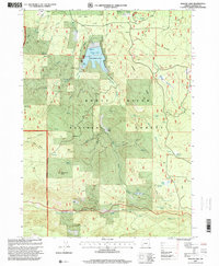
1997 Map of Willow Lake
USGS Topo · Published 2000About this map
Willow Lake serves as a focal point for this section of the Rogue River National Forest, featuring a County Recreation Area equipped with a boat dock and boat ramp. The surrounding landscape is defined by its complex hydrology and timber heritage, evidenced by the numerous named water sources like Bieberstedt Springs and Shake Camp Spring. A distinct transition in the terrain is visible where the volcanic legacy of the Cascades appears as lava flows near Skeeters Ridge.
Find a feature on this map
47 named features on this map. Tap any name to fly to it.
Don’t see what you’re looking for? This feature index may not catch every label — zoom into the map to look around manually.
Map Details
Editions of this 1997 Willow Lake Map
This is the sole edition of this map. No revisions or reprints were ever made.
Other maps of this area

1891 · Ashland
USGS Topo · 1:250,000

1893 · Ashland
USGS Topo · 1:250,000

1897 · Ashland
USGS Topo · 1:250,000

1938 · Medford
USGS Topo · 1:125,000

1954 · Butte Falls
USGS Topo · 1:62,500

1954 · Lakecreek
USGS Topo · 1:62,500

1955 · Rustler Peak
USGS Topo · 1:62,500

1955 · Mt. Mc Loughlin
USGS Topo · 1:62,500

1955 · Medford
USGS Topo · 1:250,000

1957 · Medford
USGS Topo · 1:250,000