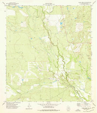
1974 Map of Caiman Creek NE
USGS Topo · Published 1977About this map
Hist Mon (Ft Ewell) marks a site of significant mid-19th-century frontier history near the banks of the Nueces River. This 1974 survey shows a landscape defined by the convergence of the river with Caiman Creek and Charco Marrano Creek, creating a complex network of ephemeral drainages and low-lying basins in the South Texas brush country. While the terrain is predominantly open ranchland, the presence of an Oil Well and several gravel pits indicates the localized extraction industries active during the 1970s. The presence of Flowing Well and La Mata Lake highlights the critical importance of water management in this arid region, where natural springs and man-made wells supported the livestock operations that shaped La Salle County's development.
Find a feature on this map
9 named features on this map. Tap any name to fly to it.
Don’t see what you’re looking for? This feature index may not catch every label — zoom into the map to look around manually.
Map Details
Editions of this 1974 Caiman Creek NE Map
This is the sole edition of this map. No revisions or reprints were ever made.
Other maps of this area

1929 · Cotulla
USGS Topo · 1:125,000

1940 · Cotulla
USGS Topo · 1:62,500

1942 · Fowlerton
USGS Topo · 1:62,500

1953 · Crystal City
USGS Topo · 1:250,000

1955 · Crystal City
USGS Topo · 1:250,000

1956 · Piedra Creek
USGS Topo · 1:62,500

1956 · Fowlerton
USGS Topo · 1:62,500

1957 · Caiman Creek
USGS Topo · 1:62,500

1961 · Crystal City
USGS Topo · 1:250,000

1968 · Crystal City
USGS Topo · 1:250,000