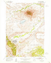
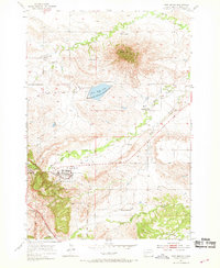
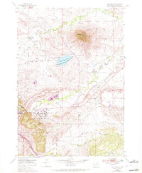
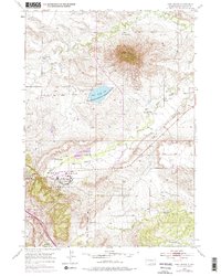
1953 Map of Fort Meade
USGS Topo · Published 1955This historical map portrays the area of Fort Meade in 1953, primarily covering Meade County. Featuring a scale of 1:24000, this map provides a highly detailed snapshot of the terrain, roads, buildings, counties, and historical landmarks in the Fort Meade region at the time. Published in 1955, it is one of 5 known editions of this map due to revisions or reprints.
Find a feature on this map
20 named features on this map. Tap any name to fly to it.
Don’t see what you’re looking for? This feature index may not catch every label — zoom into the map to look around manually.
Map Details
Editions of this 1953 Fort Meade Map
5 editions found
Historical Maps of Meade County Through Time
66 maps found

1893 Rapid
Meade County, SD

1898 Rapid
Meade County, SD

1903 Rapid
Meade County, SD

1951 Vale SE
Meade County, SD

1951 Volunteer
Meade County, SD

1951 Volunteer SE
Meade County, SD

1953 Bend
Meade County, SD

1953 Cottonwood Draw
Meade County, SD

1953 Elm Creek
Meade County, SD

1953 Fort Meade
Meade County, SD

1953 Fort Meade NE
Meade County, SD

1953 Fort Meade SE
Meade County, SD

1953 Hereford
Meade County, SD

1953 Hereford NE
Meade County, SD

1953 Hereford SE
Meade County, SD

1953 Hereford SW
Meade County, SD

1953 Lone Tree Creek
Meade County, SD

1953 New Underwood NW
Meade County, SD

1953 Rapid City NW
Meade County, SD

1953 South of Volunteer
Meade County, SD

1953 Tilford
Meade County, SD

1953 Viewfield
Meade County, SD

1954 Boneita Springs
Meade County, SD

1954 Dalzell
Meade County, SD

1954 Dalzell NE
Meade County, SD

1954 Dalzell NW
Meade County, SD

1954 Deadman Mountain
Meade County, SD

1954 Elm Springs
Meade County, SD

1954 Elm Springs SW
Meade County, SD

1954 Haydraw
Meade County, SD

1954 Saint Onge SE
Meade County, SD

1954 Wasta NW
Meade County, SD

1955 Howes
Meade County, SD

1957 Owanka NE
Meade County, SD

1957 Owanka NW
Meade County, SD

1959 Enning
Meade County, SD

1959 Fairpoint
Meade County, SD

1959 Fairpoint NW
Meade County, SD

1959 Fairpoint SE
Meade County, SD

1959 Fairpoint SW
Meade County, SD

1959 Redowl
Meade County, SD

1959 Stoneville
Meade County, SD

1959 Union Center
Meade County, SD

1973 Frozen Man Creek
Meade County, SD

1977 Table Top Butte
Meade County, SD

1978 Bull Run Creek
Meade County, SD

1978 Camp Creek
Meade County, SD

1983 Avance
Meade County, SD

1983 Avance SE
Meade County, SD

1983 Big Draw
Meade County, SD

1983 Durkee Lake
Meade County, SD

1983 Lemmon Butte
Meade County, SD

1983 Lemmon Creek
Meade County, SD

1983 Marcus
Meade County, SD

1983 Opal East
Meade County, SD

1983 Opal East SE
Meade County, SD

1983 Opal East SW
Meade County, SD

1983 Opal West SE
Meade County, SD

1983 Plainview
Meade County, SD

1983 Reed Dam
Meade County, SD

1983 Squaw Buttes
Meade County, SD

1983 Thompson Lake
Meade County, SD

1983 Whiteman Owl
Meade County, SD

1983 Whiteman Owl NW
Meade County, SD

1983 Whiteman Owl SE
Meade County, SD

1984 Camp Creek
Meade County, SD