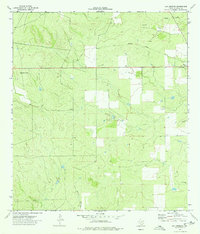
1974 Map of Los Angeles
USGS Topo · Published 1977About this map
Los Angeles stands as the primary settlement in this corner of La Salle County during the mid-1970s. The landscape is defined by the intermittent drainages of Nogate Creek to the north and Charco Marrano Creek to the south, cutting through terrain marked by an extensive network of ranch roads and fence lines. Evidence of the region's transport history remains visible through the Old Railroad Grade that traverses the northern half of the quadrangle, illustrating the shift away from rail dependency as the 20th century progressed.
Find a feature on this map
8 named features on this map. Tap any name to fly to it.
Don’t see what you’re looking for? This feature index may not catch every label — zoom into the map to look around manually.
Map Details
Editions of this 1974 Los Angeles Map
This is the sole edition of this map. No revisions or reprints were ever made.
Other maps of this area

1929 · Cotulla
USGS Topo · 1:125,000

1940 · Cotulla
USGS Topo · 1:62,500

1942 · Fowlerton
USGS Topo · 1:62,500

1942 · Dilley
USGS Topo · 1:62,500

1953 · Crystal City
USGS Topo · 1:250,000

1955 · Crystal City
USGS Topo · 1:250,000

1956 · Hindes
USGS Topo · 1:62,500

1956 · Fowlerton
USGS Topo · 1:62,500

1961 · Crystal City
USGS Topo · 1:250,000

1968 · Crystal City
USGS Topo · 1:250,000