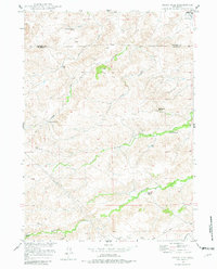
1949 Map of Cedar Hill
USGS Topo · Published 1982About this map
Ammon sits at the northeastern corner of this 1949 landscape, where the high plains of the Missouri River Basin meet the complex drainage systems of the Wyoming interior. This territory is defined by a series of significant cattle operations that established the local economy, including the Stephenson Ranch, Cundall Ranch, and Stirrup Ranch. The map captures the area just as aerial photogrammetry was becoming the standard for the Geological Survey, providing a precise look at the seasonal water sources and ranching infrastructure necessary for survival in this environment.
Find a feature on this map
26 named features on this map. Tap any name to fly to it.
Don’t see what you’re looking for? This feature index may not catch every label — zoom into the map to look around manually.
Map Details
Editions of this 1949 Cedar Hill Map
2 editions found
Other maps of this area

1943 · Esterbrook
USGS Topo · 1:62,500

1945 · Esterbrook
USGS Topo · 1:62,500

1949 · Shawnee
USGS Topo · 1:24,000

1949 · Irvine
USGS Topo · 1:24,000

1949 · Cedar Hill
USGS Topo · 1:24,000

1949 · Spring Creek
USGS Topo · 1:24,000

1949 · Dilts Ranch
USGS Topo · 1:24,000

1949 · Orin
USGS Topo · 1:24,000

1950 · Glendo
USGS Topo · 1:24,000

1950 · Spring Creek
USGS Topo · 1:24,000