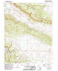
1994 Map of Hamm Canyon
USGS Topo · Published 1994About this map
Uranium Reserve lands and intensive mining operations dominate this pocket of San Miguel County during the final decade of the 20th century. The landscape is defined by the industrial geography of the Colorado Plateau, where the Dolores River and Disappointment Creek carve through the deep basins of Big Gypsum Valley and Disappointment Valley. This era of mineral extraction is meticulously documented through numerous named claims and infrastructure, including the Chile No 5 Mine, Mexico Mines, and the Carnation Mine. Networks of 4wd tracks provide access across the high ground of Cape Horn and Hamm Canyon, connecting various prospects and air shafts to the valley floors. These features illustrate the persistent search for ore and the specialized management of the Department of Energy in this resource-rich corridor.
Find a feature on this map
40 named features on this map. Tap any name to fly to it.
Don’t see what you’re looking for? This feature index may not catch every label — zoom into the map to look around manually.
Map Details
Editions of this 1994 Hamm Canyon Map
This is the sole edition of this map. No revisions or reprints were ever made.
Other maps of this area

1916 · Paradox Valley
USGS Topo · 1:125,000

1922 · Paradox Valley
USGS Topo · 1:125,000

1948 · Bull Canyon
USGS Topo · 1:24,000

1948 · Horse Range Mesa
USGS Topo · 1:24,000

1948 · Hamm Canyon
USGS Topo · 1:24,000

1948 · Naturita NW
USGS Topo · 1:24,000

1948 · Gypsum Gap
USGS Topo · 1:24,000

1949 · Bull Canyon
USGS Topo · 1:24,000

1949 · Gypsum Gap
USGS Topo · 1:24,000

1949 · Naturita NW
USGS Topo · 1:24,000