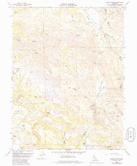
1958 Map of Jericho Valley
USGS Topo · Published 1986About this map
Jerusalem Valley and Jericho Valley define the interior of this 1958 survey, where the drainages of Putah Creek and its many tributaries carve a complex series of ridges including the Watson Range and Bishop Mountain. The map documents a period of ranching and early resource extraction, noting the Red Elephant Mine near Oat Hill and the active Quarry in the north. Settlement is sparse and focused on established agricultural holdings such as Hennesey Ranch and Ink Ranch. In the southwest, a large Military Reservation sits adjacent to localized water bodies like Wildcat Lake and McCreary Lake. The landscape is notable for its distinct terrain features like the colorful Hells Half Acre and the expansive wooded area identified as The Cedars, showing the region before modern development patterns altered the rural character of the Lake and Napa county line.
Find a feature on this map
50 named features on this map. Tap any name to fly to it.
Don’t see what you’re looking for? This feature index may not catch every label — zoom into the map to look around manually.
Map Details
Editions of this 1958 Jericho Valley Map
4 editions found
Other maps of this area

1927 · Calistoga
USGS Topo · 1:62,500

1942 · St. Helena
USGS Topo · 1:62,500

1943 · Morgan Valley
USGS Topo · 1:62,500

1943 · Calistoga
USGS Topo · 1:62,500

1944 · Morgan Valley
USGS Topo · 1:62,500

1945 · Calistoga
USGS Topo · 1:62,500

1945 · St. Helena
USGS Topo · 1:62,500

1945 · Lower Lake
USGS Topo · 1:62,500

1947 · Santa Rosa
USGS Topo · 1:250,000

1949 · Santa Rosa
USGS Topo · 1:250,000