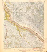
1939 Map of Pointe a La Hache
USGS Topo · Published 1941This historical map portrays the area of Pointe a La Hache in 1939, primarily covering Plaquemines Parish as well as portions of Jefferson Parish. Featuring a scale of 1:62500, this map provides a highly detailed snapshot of the terrain, roads, buildings, counties, and historical landmarks in the Pointe a La Hache region at the time. Published in 1941, it is one of 2 known editions of this map due to revisions or reprints.
Find a feature on this map
112 named features on this map. Tap any name to fly to it.
Don’t see what you’re looking for? This feature index may not catch every label — zoom into the map to look around manually.
Map Details
Editions of this 1939 Pointe a La Hache Map
2 editions found
Historical Maps of Bohemia Through Time
108 maps found

1891 Pointe a La Hache
Plaquemines Parish, LA

1892 Pointe a La Hache
Plaquemines Parish, LA

1892 Quarantine
Plaquemines Parish, LA

1893 Dime
Plaquemines Parish, LA

1893 East Delta
Plaquemines Parish, LA

1893 Fort Livingston
Plaquemines Parish, LA

1893 Forts
Plaquemines Parish, LA

1893 West Delta
Plaquemines Parish, LA

1935 Bastian Bay
Plaquemines Parish, LA

1935 Bay Ronquille
Plaquemines Parish, LA

1935 Garden Island Pass
Plaquemines Parish, LA

1935 Lake Batola
Plaquemines Parish, LA

1935 South Pass
Plaquemines Parish, LA

1935 Taylor Pass
Plaquemines Parish, LA

1935 Tropical Bend
Plaquemines Parish, LA

1935 Wilkinson Bay
Plaquemines Parish, LA

1939 Pointe a La Hache
Plaquemines Parish, LA

1941 Black Bay
Plaquemines Parish, LA

1944 Black Bay
Plaquemines Parish, LA

1944 Pointe a La Hache
Plaquemines Parish, LA

1946 Mudpan Bayou
Plaquemines Parish, LA

1946 Pass Du Bois
Plaquemines Parish, LA

1946 Pass Tante Phine
Plaquemines Parish, LA

1947 Bay Ronquille
Plaquemines Parish, LA

1947 Fort St. Philip
Plaquemines Parish, LA

1947 Garden Island Pass
Plaquemines Parish, LA

1947 Main Pass
Plaquemines Parish, LA

1947 Pass A Loutre East
Plaquemines Parish, LA

1947 Pass A Loutre West
Plaquemines Parish, LA

1947 Southwest Pass
Plaquemines Parish, LA

1947 Wilkinson Bay
Plaquemines Parish, LA

1948 Fort Livingston
Plaquemines Parish, LA

1948 Forts
Plaquemines Parish, LA

1948 Pointe a La Hache
Plaquemines Parish, LA

1949 Bay Batiste
Plaquemines Parish, LA

1949 Burrwood
Plaquemines Parish, LA

1949 Coquille Point
Plaquemines Parish, LA

1949 Cubits Gap
Plaquemines Parish, LA

1950 Breton Islands
Plaquemines Parish, LA

1951 Grand Gosier Islands
Plaquemines Parish, LA

1952 Southwest Pass
Plaquemines Parish, LA

1953 Breton Island
Plaquemines Parish, LA

1953 West Delta
Plaquemines Parish, LA

1954 East Delta
Plaquemines Parish, LA

1954 Fort St. Philip
Plaquemines Parish, LA

1954 Mudpan Bayou
Plaquemines Parish, LA

1954 Pass A Loutre East
Plaquemines Parish, LA

1954 Pass A Loutre West
Plaquemines Parish, LA

1954 Pass Du Bois
Plaquemines Parish, LA

1954 Pass Tante Phine
Plaquemines Parish, LA

1954 Southwest Pass
Plaquemines Parish, LA

1954 Taylor Pass
Plaquemines Parish, LA

1957 Breton Sound
Plaquemines Parish, LA

1958 Breton Island
Plaquemines Parish, LA

1958 East Delta
Plaquemines Parish, LA

1958 Main Pass
Plaquemines Parish, LA

1958 Southwest Pass
Plaquemines Parish, LA

1958 West Delta
Plaquemines Parish, LA

1961 Breton Sound
Plaquemines Parish, LA

1962 Pointe a La Hache
Plaquemines Parish, LA

1964 Black Bay
Plaquemines Parish, LA

1964 Pointe a La Hache
Plaquemines Parish, LA

1971 Breton Islands
Plaquemines Parish, LA

1971 Breton Islands SE
Plaquemines Parish, LA

1971 Burrwood Bayou East
Plaquemines Parish, LA

1971 Burrwood Bayou West
Plaquemines Parish, LA

1971 Coquille Point
Plaquemines Parish, LA

1971 Dixon Bay
Plaquemines Parish, LA

1971 Garden Island Pass
Plaquemines Parish, LA

1971 Main Pass
Plaquemines Parish, LA

1971 Pass A Loutre East
Plaquemines Parish, LA

1971 Pass A Loutre West
Plaquemines Parish, LA

1971 Pass Du Bois
Plaquemines Parish, LA

1971 Pass Tante Phine
Plaquemines Parish, LA

1971 Pilottown
Plaquemines Parish, LA

1971 South of South Pass
Plaquemines Parish, LA

1971 South Pass
Plaquemines Parish, LA

1971 Taylor Pass
Plaquemines Parish, LA

1973 Bastian Bay
Plaquemines Parish, LA

1973 Bay Batiste
Plaquemines Parish, LA

1973 Bay Coquette
Plaquemines Parish, LA

1973 Bay Ronquille
Plaquemines Parish, LA

1973 Black Bay South
Plaquemines Parish, LA

1973 Happy Jack
Plaquemines Parish, LA

1973 Lake Batola
Plaquemines Parish, LA

1973 Lake Cuatro Caballo
Plaquemines Parish, LA

1973 Lake Laurier
Plaquemines Parish, LA

1973 Phoenix
Plaquemines Parish, LA

1973 Pointe a La Hache
Plaquemines Parish, LA

1973 Wilkinson Bay
Plaquemines Parish, LA

1979 Southwest Pass
Plaquemines Parish, LA

1983 Mississippi River Delta
Plaquemines Parish, LA

1993 Bastian Bay
Plaquemines Parish, LA

1993 Bay Batiste
Plaquemines Parish, LA

1993 Bay Coquette
Plaquemines Parish, LA

1993 Bay Ronquille
Plaquemines Parish, LA

1993 Breton Islands
Plaquemines Parish, LA

1993 Coquille Point
Plaquemines Parish, LA

1993 Pass A Loutre West
Plaquemines Parish, LA

1993 Pass Du Bois
Plaquemines Parish, LA

1993 Pilottown
Plaquemines Parish, LA

1993 Taylor Pass
Plaquemines Parish, LA

1998 Burrwood Bayou East
Plaquemines Parish, LA

1998 Burrwood Bayou West
Plaquemines Parish, LA

1998 Dixon Bay
Plaquemines Parish, LA

1998 Grand Gosier Islands
Plaquemines Parish, LA

1998 Pass Tante Phine
Plaquemines Parish, LA

1998 South Pass
Plaquemines Parish, LA