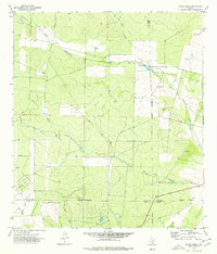
1974 Map of Snake Creek
USGS Topo · Published 1977About this map
Cibolo Creek and its southern tributaries wind through the Brush Country landscape of South Texas, defining a region where four county lines—Zavala, Frio, Dimmit, and La Salle—converge. In the mid-1970s, the local economy appears rooted in petroleum extraction and livestock management, anchored by the expansive Big Wells Oil Field and scattered infrastructure such as Storage Bins and a Drill Hole. The small settlement of Baggett sits near the western edge of the quadrangle, serving as a rare residential node in a territory dominated by intermittent waterways like Snake Creek and Espio Creek. The terrain is characterized by broad drainage basins and the notable depression of Big Hollow, with an Indefinite Boundary marking the shifts in jurisdictional lines across the mesquite-covered plains. For researchers, the map provides a clear record of fence lines, improved light-duty roads, and the industrial footprint of the Texas oil patch during this era.
Find a feature on this map
15 named features on this map. Tap any name to fly to it.
Don’t see what you’re looking for? This feature index may not catch every label — zoom into the map to look around manually.
Map Details
Editions of this 1974 Snake Creek Map
This is the sole edition of this map. No revisions or reprints were ever made.
Other maps of this area

1939 · Big Wells
USGS Topo · 1:62,500

1942 · Divot
USGS Topo · 1:62,500

1953 · Crystal City
USGS Topo · 1:250,000

1955 · Crystal City
USGS Topo · 1:250,000

1956 · Woodward
USGS Topo · 1:62,500

1956 · Divot
USGS Topo · 1:62,500

1957 · Batesville
USGS Topo · 1:62,500

1961 · Crystal City
USGS Topo · 1:250,000

1968 · Crystal City
USGS Topo · 1:250,000
1972 · Big Wells
USGS Topo · 1:24,000