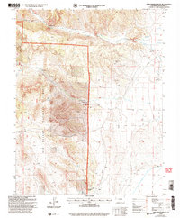
2001 Map of Twin Mountains SE
USGS Topo · Published 2005About this map
Rio Grande National Forest dominates the western portion of this Saguache County landscape, where the high desert terrain meets the rugged eastern slopes of the San Juan Mountains. The map reveals a transition from the narrow, winding corridors of Coolbroth Canyon and Hellgate to the more open drainage basins of Carnero Creek and La Garita Creek. Human presence is marked by isolated landmarks like the St John Ch and a small Cem near the confluence of Wilson Creek, suggesting a sparsely populated ranching or homesteading community.
Find a feature on this map
17 named features on this map. Tap any name to fly to it.
Don’t see what you’re looking for? This feature index may not catch every label — zoom into the map to look around manually.
Map Details
Editions of this 2001 Twin Mountains SE Map
This is the sole edition of this map. No revisions or reprints were ever made.
Other maps of this area

1915 · Del Norte
USGS Topo · 1:125,000

1917 · Del Norte
USGS Topo · 1:125,000

1945 · Durango
USGS Topo · 1:250,000

1953 · Durango
USGS Topo · 1:250,000

1954 · Durango
USGS Topo · 1:250,000

1961 · Durango
USGS Topo · 1:250,000

1963 · Durango
USGS Topo · 1:250,000

1964 · Sevenmile Plaza
USGS Topo · 1:24,000

1966 · Durango
USGS Topo · 1:250,000
1966 · Del Norte
USGS Topo · 1:24,000