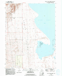
1994 Map of Goshen Valley North
USGS Topo · Published 1994About this map
Goshen Valley unfolds along the southwestern shoreline of Utah Lake in this mid-1990s mapping of a landscape defined by its hydrology and ranching infrastructure. The map depicts a distinct transition from the steep, canyon-cut hillsides of Coyote Pass and the western mountains down to the alluvial floor and extensive wetlands. Human activity is evidenced by a network of agricultural improvements, including a Corral, several wells, and a Water tank, alongside an industrial footprint marked by a Substation and a mining Prospect to the north. The eastern edge is dominated by the lake's shifting margin, featuring a broad Mud Flat and White Lake. These drainage patterns, including the course of Pinyon Creek, illustrate the complex water management essential for the Genola Corporate Boundary area and the adjacent livestock operations at Allens Ranch.
Find a feature on this map
15 named features on this map. Tap any name to fly to it.
Don’t see what you’re looking for? This feature index may not catch every label — zoom into the map to look around manually.
Map Details
Editions of this 1994 Goshen Valley North Map
This is the sole edition of this map. No revisions or reprints were ever made.
Other maps of this area

1885 · Salt Lake
USGS Topo · 1:250,000

1885 · Manti
USGS Topo · 1:250,000

1885 · Sevier Desert
USGS Topo · 1:250,000

1885 · Tooele Valley
USGS Topo · 1:250,000

1895 · Manti
USGS Topo · 1:250,000

1947 · Fivemile Pass
USGS Topo · 1:62,500

1947 · Allens Ranch
USGS Topo · 1:24,000

1947 · Goshen Pass
USGS Topo · 1:24,000

1949 · Eureka
USGS Topo · 1:24,000

1949 · Allens Ranch
USGS Topo · 1:24,000