
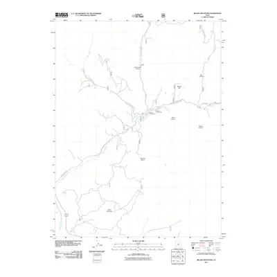
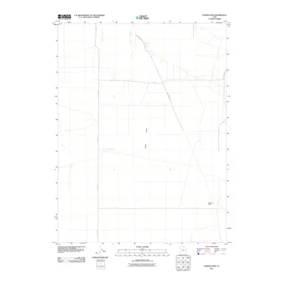
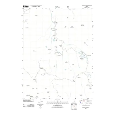
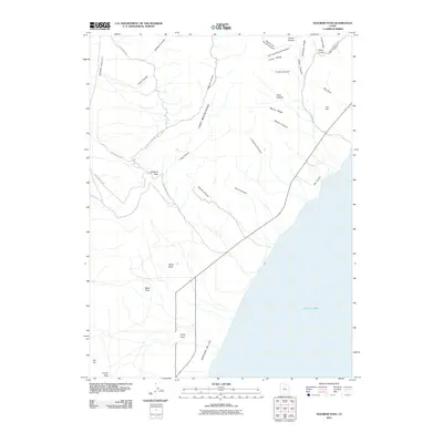
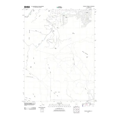
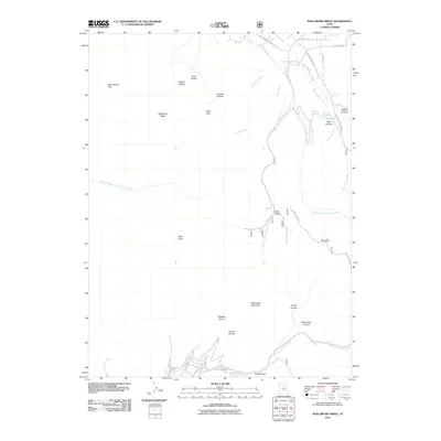
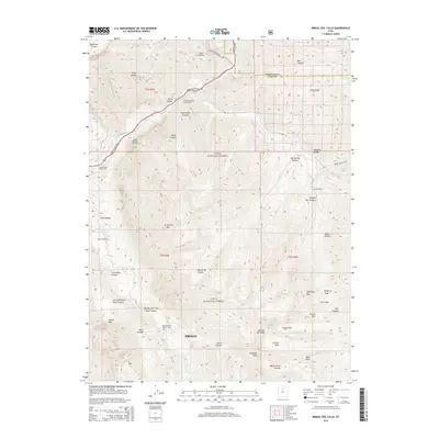
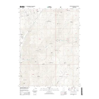
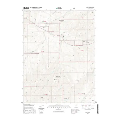
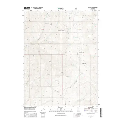
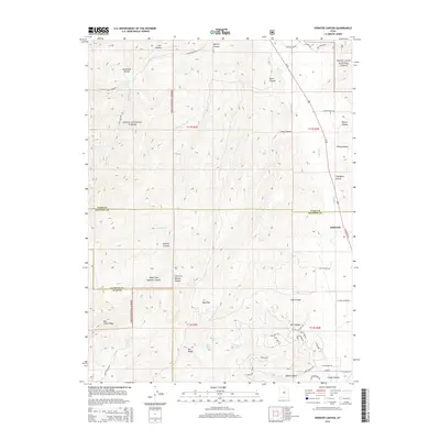
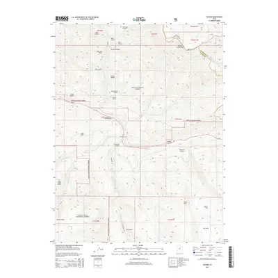
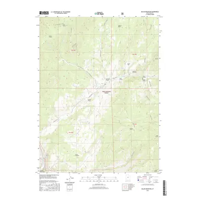
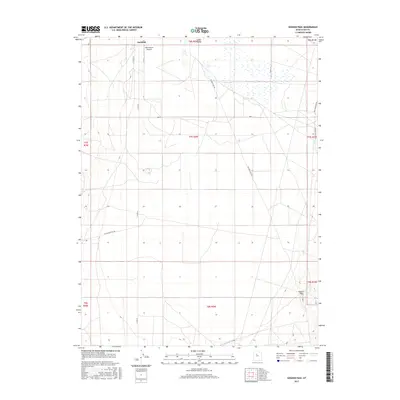
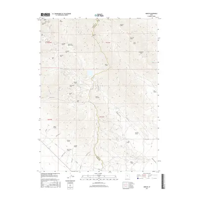
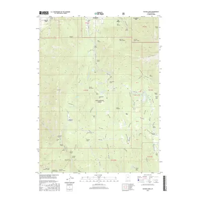
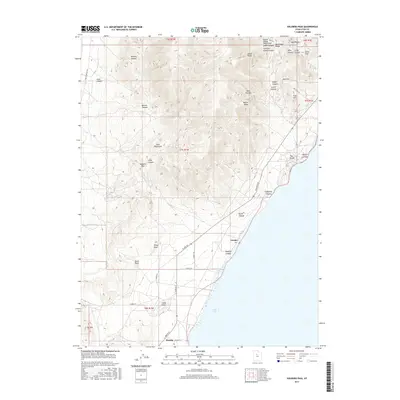
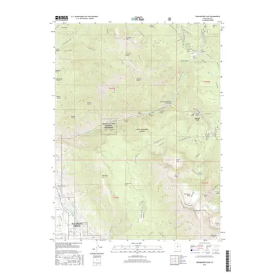
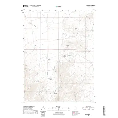
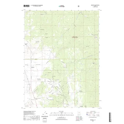
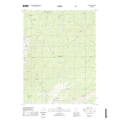
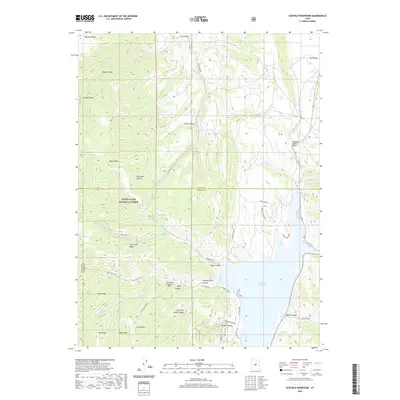
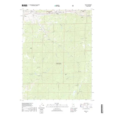
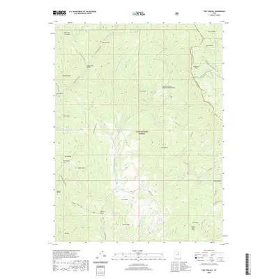
1998 Map of Nebo Basin
USGS Topo · Published 2002About this map
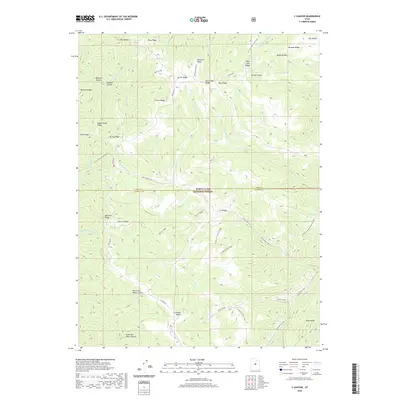
Mount Nebo Wilderness dominates the western portion of this terrain, where high peaks like North Peak and the alpine waters of Salamander Lake define the drainage patterns of the Uinta National Forest. The 1998 revision by the Forest Service highlights a landscape managed for both preservation and recreation, centered around the Nebo Loop Scenic Byway. This route provides access to distinct geological features like the red rock formations of Devils Kitchen and the high-elevation views at Nebo Bench.
Find a feature on this map
72 named features on this map. Tap any name to fly to it.
Don’t see what you’re looking for? This feature index may not catch every label — zoom into the map to look around manually.
Map Details
Editions of this 1998 Nebo Basin Map
This is the sole edition of this map. No revisions or reprints were ever made.
Historical Maps of Utah County Through Time
207 maps found

1885 Salt Lake
Utah County, UT

1939 Soldier Summit
Utah County, UT

1942 Soldier Summit
Utah County, UT

1947 Allens Ranch
Utah County, UT

1947 Fivemile Pass
Utah County, UT

1947 Goshen Pass
Utah County, UT

1948 Bridal Veil Falls
Utah County, UT

1948 Timpanogos Cave
Utah County, UT

1949 Allens Ranch
Utah County, UT

1949 Goshen Pass
Utah County, UT

1949 Spanish Fork Peak
Utah County, UT

1950 Bridal Veil Falls
Utah County, UT

1950 Goshen Valley North
Utah County, UT

1950 Lincoln Point
Utah County, UT

1950 Pelican Point
Utah County, UT

1950 Soldiers Pass
Utah County, UT

1950 Timpanogos Cave
Utah County, UT

1951 Pelican Point
Utah County, UT

1951 Spanish Fork Peak
Utah County, UT

1952 Lincoln Point
Utah County, UT

1952 Santaquin Peak
Utah County, UT

1954 Tickville Spring
Utah County, UT

1967 Billies Mtn.
Utah County, UT

1967 C Canyon
Utah County, UT

1967 Granger Mtn
Utah County, UT

1967 Indianola
Utah County, UT

1967 Mill Fork
Utah County, UT

1967 Rays Valley
Utah County, UT

1967 Thistle
Utah County, UT

1967 Two Tom Hill
Utah County, UT

1967 Wallsburg Ridge
Utah County, UT

1968 Mercur
Utah County, UT

1978 Scofield Reservoir
Utah County, UT

1979 Birdseye
Utah County, UT

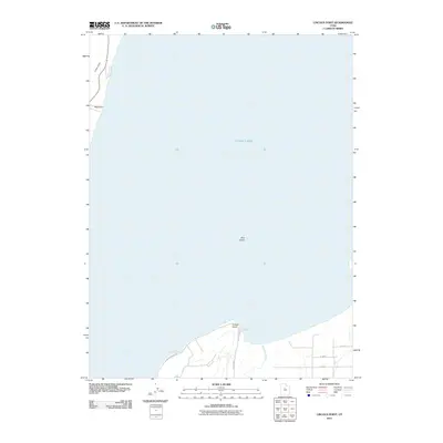
1979 Nebo Basin
Utah County, UT

1979 Payson Lakes
Utah County, UT

1979 Spencer Canyon
Utah County, UT

1992 Pelican Point
Utah County, UT

1993 Allens Ranch
Utah County, UT

1993 Bridal Veil Falls
Utah County, UT

1993 Goshen Pass
Utah County, UT

1993 Lincoln Point
Utah County, UT

1993 Mercur
Utah County, UT

1993 Soldiers Pass
Utah County, UT

1993 Tickville Spring
Utah County, UT

1993 Timpanogos Cave
Utah County, UT

1993 Two Tom Hill
Utah County, UT

1993 Wallsburg Ridge
Utah County, UT

1994 Billies Mtn.
Utah County, UT

1994 Goshen Valley North
Utah County, UT

1994 Granger Mtn
Utah County, UT

1994 Rays Valley
Utah County, UT

1994 Spanish Fork Peak
Utah County, UT

1997 Goshen Pass
Utah County, UT

1997 Lincoln Point
Utah County, UT

1997 Mercur
Utah County, UT

1997 Soldiers Pass
Utah County, UT

1997 Tickville Spring
Utah County, UT

1998 Billies Mountain
Utah County, UT

1998 Bridal Veil Falls
Utah County, UT

1998 Granger Mountain
Utah County, UT
1998 Nebo Basin
Utah County, UT

1998 Payson Lakes
Utah County, UT

1998 Rays Valley
Utah County, UT

1998 Spanish Fork Peak
Utah County, UT

1998 Timpanogos Cave
Utah County, UT

1998 Two Tom Hill
Utah County, UT

1998 Wallsburg Ridge
Utah County, UT

1999 Pelican Point
Utah County, UT

2001 Birdseye
Utah County, UT

2001 C Canyon
Utah County, UT

2001 Indianola
Utah County, UT

2001 Mill Fork
Utah County, UT

2001 Scofield Reservoir
Utah County, UT

2001 Spencer Canyon
Utah County, UT

2001 Thistle
Utah County, UT

2001 Tucker
Utah County, UT

2011 Allens Ranch
Utah County, UT
2011 Billies Mountain
Utah County, UT
2011 Birdseye
Utah County, UT
2011 Bridal Veil Falls
Utah County, UT
2011 C Canyon
Utah County, UT
2011 Goshen Pass
Utah County, UT
2011 Goshen Valley North
Utah County, UT
2011 Granger Mountain
Utah County, UT
2011 Indianola
Utah County, UT
2011 Lincoln Point
Utah County, UT
2011 Mercur
Utah County, UT
2011 Mill Fork
Utah County, UT
2011 Nebo Basin
Utah County, UT
2011 Payson Lakes
Utah County, UT
2011 Pelican Point
Utah County, UT
2011 Rays Valley
Utah County, UT
2011 Scofield Reservoir
Utah County, UT
2011 Soldiers Pass
Utah County, UT
2011 Spanish Fork Peak
Utah County, UT
2011 Spencer Canyon
Utah County, UT
2011 Thistle
Utah County, UT
2011 Tickville Spring
Utah County, UT
2011 Timpanogos Cave
Utah County, UT
2011 Tucker
Utah County, UT
2011 Two Tom Hill
Utah County, UT
2011 Wallsburg Ridge
Utah County, UT
2014 Allens Ranch
Utah County, UT
2014 Billies Mountain
Utah County, UT
2014 Birdseye
Utah County, UT
2014 Bridal Veil Falls
Utah County, UT
2014 C Canyon
Utah County, UT
2014 Goshen Pass
Utah County, UT
2014 Goshen Valley North
Utah County, UT
2014 Granger Mountain
Utah County, UT
2014 Indianola
Utah County, UT
2014 Lincoln Point
Utah County, UT
2014 Mercur
Utah County, UT
2014 Mill Fork
Utah County, UT
2014 Nebo Basin
Utah County, UT
2014 Payson Lakes
Utah County, UT
2014 Pelican Point
Utah County, UT
2014 Rays Valley
Utah County, UT
2014 Scofield Reservoir
Utah County, UT
2014 Soldiers Pass
Utah County, UT
2014 Spanish Fork Peak
Utah County, UT
2014 Spencer Canyon
Utah County, UT
2014 Thistle
Utah County, UT
2014 Tickville Spring
Utah County, UT
2014 Timpanogos Cave
Utah County, UT
2014 Tucker
Utah County, UT
2014 Two Tom Hill
Utah County, UT
2014 Wallsburg Ridge
Utah County, UT
2017 Allens Ranch
Utah County, UT
2017 Billies Mountain
Utah County, UT
2017 Birdseye
Utah County, UT
2017 Bridal Veil Falls
Utah County, UT
2017 C Canyon
Utah County, UT
2017 Goshen Pass
Utah County, UT
2017 Goshen Valley North
Utah County, UT
2017 Granger Mountain
Utah County, UT
2017 Indianola
Utah County, UT
2017 Lincoln Point
Utah County, UT
2017 Mercur
Utah County, UT
2017 Mill Fork
Utah County, UT
2017 Nebo Basin
Utah County, UT
2017 Payson Lakes
Utah County, UT
2017 Pelican Point
Utah County, UT
2017 Rays Valley
Utah County, UT
2017 Scofield Reservoir
Utah County, UT
2017 Soldiers Pass
Utah County, UT
2017 Spanish Fork Peak
Utah County, UT
2017 Spencer Canyon
Utah County, UT
2017 Thistle
Utah County, UT

2017 Tickville Spring
Utah County, UT
2017 Timpanogos Cave
Utah County, UT
2017 Tucker
Utah County, UT
2017 Two Tom Hill
Utah County, UT
2017 Wallsburg Ridge
Utah County, UT
2020 Allens Ranch
Utah County, UT
2020 Billies Mountain
Utah County, UT
2020 Birdseye
Utah County, UT
2020 Bridal Veil Falls
Utah County, UT
2020 C Canyon
Utah County, UT
2020 Goshen Pass
Utah County, UT
2020 Goshen Valley North
Utah County, UT
2020 Granger Mountain
Utah County, UT
2020 Indianola
Utah County, UT
2020 Lincoln Point
Utah County, UT
2020 Mercur
Utah County, UT
2020 Mill Fork
Utah County, UT
2020 Nebo Basin
Utah County, UT
2020 Payson Lakes
Utah County, UT
2020 Pelican Point
Utah County, UT
2020 Rays Valley
Utah County, UT
2020 Scofield Reservoir
Utah County, UT
2020 Soldiers Pass
Utah County, UT
2020 Spanish Fork Peak
Utah County, UT
2020 Spencer Canyon
Utah County, UT
2020 Thistle
Utah County, UT
2020 Tickville Spring
Utah County, UT
2020 Timpanogos Cave
Utah County, UT
2020 Tucker
Utah County, UT
2020 Two Tom Hill
Utah County, UT
2020 Wallsburg Ridge
Utah County, UT

2023 Allens Ranch
Utah County, UT

2023 Billies Mountain
Utah County, UT

2023 Birdseye
Utah County, UT

2023 Bridal Veil Falls
Utah County, UT
2023 C Canyon
Utah County, UT
2023 Goshen Pass
Utah County, UT

2023 Goshen Valley North
Utah County, UT

2023 Granger Mountain
Utah County, UT

2023 Indianola
Utah County, UT

2023 Lincoln Point
Utah County, UT

2023 Mercur
Utah County, UT

2023 Mill Fork
Utah County, UT

2023 Nebo Basin
Utah County, UT

2023 Payson Lakes
Utah County, UT

2023 Pelican Point
Utah County, UT

2023 Rays Valley
Utah County, UT

2023 Scofield Reservoir
Utah County, UT

2023 Soldiers Pass
Utah County, UT

2023 Spanish Fork Peak
Utah County, UT

2023 Spencer Canyon
Utah County, UT

2023 Thistle
Utah County, UT

2023 Tickville Spring
Utah County, UT

2023 Timpanogos Cave
Utah County, UT

2023 Tucker
Utah County, UT

2023 Two Tom Hill
Utah County, UT

2023 Wallsburg Ridge
Utah County, UT