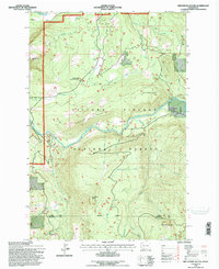
1994 Map of Greenhorn Buttes
USGS Topo · Published 1996About this map
Gifford Pinchot National Forest dominates this landscape in the mid-1990s, where the convergence of the Cowlitz River and the Cispus River shapes the local topography. This 1994 revision reflects a heavily managed timber and recreational environment, evidenced by the presence of the Woods Creek Information Station and a dense network of forest roads like Woods Creek Rd 1060. The map traces the county boundary between Lewis Co and Skamania Co, cutting through high-elevation terrain including Bluff Mountain and the namesake Greenhorn Buttes. For those studying the history of land use in the Pacific Northwest, the intricate drainage system of Greenhorn Creek, Nash Creek, and Trapper Creek illustrates the complex watersheds that define this portion of the Cascades before the turn of the 21st century.
Find a feature on this map
24 named features on this map. Tap any name to fly to it.
Don’t see what you’re looking for? This feature index may not catch every label — zoom into the map to look around manually.
Map Details
Editions of this 1994 Greenhorn Buttes Map
This is the sole edition of this map. No revisions or reprints were ever made.
Other maps of this area

1919 · Mount St Helens
USGS Topo · 1:125,000

1924 · Mt Rainier
USGS Topo · 1:96,000

1926 · Steamboat Mtn
USGS Topo · 1:125,000

1928 · Mt Rainier
USGS Topo · 1:125,000

1931 · Steamboat Mtn
USGS Topo · 1:125,000

1937 · Eatonville
USGS Topo · 1:125,000

1950 · Yakima
USGS Topo · 1:250,000

1953 · Hoquiam
USGS Topo · 1:250,000

1956 · Mineral
USGS Topo · 1:62,500

1957 · Hoquiam
USGS Topo · 1:250,000