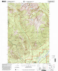
1998 Map of Tatoosh Lakes
USGS Topo · Published 2003About this map
Tatoosh Range peaks and the alpine basins of the southern Cascades dominate this landscape during the late 1990s. The map illustrates the complex intersection of jurisdictional boundaries where Mt Rainier National Park meets the Tatoosh Wilderness and the Gifford Pinchot National Forest. At the northern edge, the remnants of the Unicorn Glacier cling to Unicorn Peak and Stevens Peak, while the headwaters of Butter Creek and Teos Creek flow through the deep glaciated valleys.
Find a feature on this map
56 named features on this map. Tap any name to fly to it.
Don’t see what you’re looking for? This feature index may not catch every label — zoom into the map to look around manually.
Map Details
Editions of this 1998 Tatoosh Lakes Map
This is the sole edition of this map. No revisions or reprints were ever made.
Other maps of this area

1924 · Mt Rainier
USGS Topo · 1:96,000

1928 · Mt Rainier
USGS Topo · 1:125,000

1950 · Yakima
USGS Topo · 1:250,000

1958 · Yakima
USGS Topo · 1:250,000

1961 · Yakima
USGS Topo · 1:250,000

1962 · Randle
USGS Topo · 1:62,500

1962 · Packwood
USGS Topo · 1:62,500
1971 · Mt Rainier West
USGS Topo · 1:24,000
1971 · Chinook Pass
USGS Topo · 1:24,000
1971 · Mt Rainier East
USGS Topo · 1:24,000