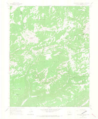
1964 Map of Groundhog Mountain
USGS Topo · Published 1968About this map
Uncompahgre National Forest and San Juan National Forest meet in this high-altitude landscape of the mid-1960s, centered on the massive Black Mesa and Groundhog Mountain. This survey captures a region defined by complex drainage systems and early water management, where numerous headwaters like Beaver Creek and Groundhog Creek descend from the heights. Evidence of local land use is preserved through labels like The Vega and a dedicated Pack Trail that crosses the southern slopes of the mesa. Several high-country reservoirs, including Nelson Reservoir, Joe Redd Reservoir, and Groundhog Point Reservoir, highlight the importance of water storage in this section of the San Miguel and Dolores county line. The topography is anchored by Willow Divide in the southeast, which separates the flow toward the West Dolores River.
Find a feature on this map
21 named features on this map. Tap any name to fly to it.
Don’t see what you’re looking for? This feature index may not catch every label — zoom into the map to look around manually.
Map Details
Editions of this 1964 Groundhog Mountain Map
2 editions found
Other maps of this area

1897 · Rico
USGS Topo · 1:62,500

1898 · Rico
USGS Topo · 1:62,500

1899 · Rico
USGS Topo · 1:62,500

1953 · Dolores Peak
USGS Topo · 1:24,000

1953 · Little Cone
USGS Topo · 1:24,000

1956 · Cortez
USGS Topo · 1:250,000

1958 · Cortez
USGS Topo · 1:250,000

1959 · Cortez
USGS Topo · 1:250,000
1960 · Rico
USGS Topo · 1:24,000

1962 · Cortez
USGS Topo · 1:250,000