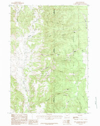
1984 Map of Moon
USGS Topo · Published 1984About this map
The Black Hills National Forest straddles the rugged state line where Wyoming and South Dakota meet. This high-altitude landscape is defined by its complex network of drainage systems, with Stockade Beaver Creek and Beaver Creek carving through the western terrain while Boles Canyon and Sled Canyon dominate the southeastern reach. The small settlement of Moon sits near the eastern boundary, serving as a rare point of human habitation amidst a territory largely shaped by forestry and water management. For those interested in the hydrology of the Black Hills, the map identifies numerous isolated water sources including Rudenvale Spring, Thomson Spring, and Summit Spring, many situated along the steep slopes of Summit Ridge. The presence of several family-named canyons, such as Kinney Canyon and Thomson Canyon, suggests a history of localized grazing or timber activity in the late twentieth century.
Find a feature on this map
25 named features on this map. Tap any name to fly to it.
Don’t see what you’re looking for? This feature index may not catch every label — zoom into the map to look around manually.
Map Details
Editions of this 1984 Moon Map
This is the sole edition of this map. No revisions or reprints were ever made.
Other maps of this area

1894 · Deadwood
USGS Topo · 1:125,000

1896 · Harney Peak
USGS Topo · 1:125,000

1898 · Sundance
USGS Topo · 1:125,000

1899 · Newcastle
USGS Topo · 1:125,000

1901 · Harney Peak
USGS Topo · 1:125,000

1901 · Deadwood
USGS Topo · 1:125,000

1901 · Newcastle
USGS Topo · 1:125,000

1902 · Sundance
USGS Topo · 1:125,000

1916 · Deadwood
USGS Topo · 1:125,000

1951 · Newcastle
USGS Topo · 1:24,000