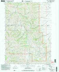
2001 Map of Sublett Troughs
USGS Topo · Published 2006About this map
California National Historic Trail corridors weave through this section of the Sawtooth National Forest, tracing a legacy of western migration across the Sawtooth Range and Sublett Range. The map highlights the Hudspeth Cut-Off, a significant alternate route for emigrants seeking a more direct path during the gold rush era. This high-elevation terrain is defined by its critical water sources, including Sublett Spring, Eyrie Spring, and the Pine Creek Reservoir, which supported both livestock and travelers in an arid environment. From the heights of Eyrie Peak down to the distinct Rock Sublett Troughs, the landscape is a network of deep drainages such as Ward Canyon and Heydlauff Canyon. Smaller features like the Storage Bin and numerous named seeps like Kossman Seep reflect the managed grazing and forestry uses of the late twentieth century.
Find a feature on this map
38 named features on this map. Tap any name to fly to it.
Don’t see what you’re looking for? This feature index may not catch every label — zoom into the map to look around manually.
Map Details
Editions of this 2001 Sublett Troughs Map
This is the sole edition of this map. No revisions or reprints were ever made.
Other maps of this area

1954 · Pocatello
USGS Topo · 1:250,000

1958 · Pocatello
USGS Topo · 1:250,000

1958 · Sublett
USGS Topo · 1:62,500

1959 · Strevell
USGS Topo · 1:62,500

1973 · Juniper
USGS Topo · 1:24,000

1973 · Hartley Peak
USGS Topo · 1:24,000

1973 · Sublett Troughs
USGS Topo · 1:24,000
1973 · Roy
USGS Topo · 1:24,000
1973 · Badger Hole Spring
USGS Topo · 1:24,000
1973 · Roy NE
USGS Topo · 1:24,000