
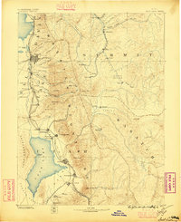
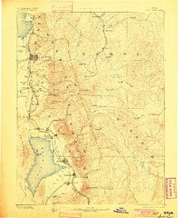
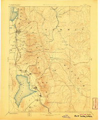
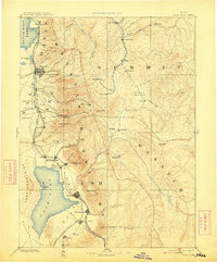
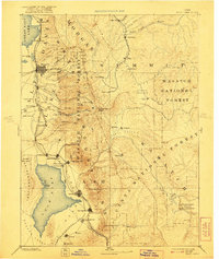
1885 Map of Salt Lake
USGS Topo · Published 1885About this map
Salt Lake City and the expanding settlements of the Wasatch Mountains anchor this late-nineteenth-century survey. The landscape reflects an era of intense mineral extraction and transport development, visible in the high-elevation mining hubs of Alta and Silver City, and the industrial connection at Coalville. Early railroad networks, including the Denver and Rio Grande Western R. R. and the U. P. R. R., trace the valleys and canyons, linking agricultural centers like Provo and Heber to the capital.
Find a feature on this map
76 named features on this map. Tap any name to fly to it.
Don’t see what you’re looking for? This feature index may not catch every label — zoom into the map to look around manually.
Map Details
Editions of this 1885 Salt Lake Map
7 editions found
Historical Maps of McMillan Meadows Through Time
103 maps found

1885 Salt Lake
Utah County, UT

1939 Soldier Summit
Utah County, UT

1942 Soldier Summit
Utah County, UT

1947 Allens Ranch
Utah County, UT

1947 Fivemile Pass
Utah County, UT

1947 Goshen Pass
Utah County, UT

1948 Bridal Veil Falls
Utah County, UT

1948 Timpanogos Cave
Utah County, UT

1949 Allens Ranch
Utah County, UT

1949 Goshen Pass
Utah County, UT

1949 Spanish Fork Peak
Utah County, UT

1950 Bridal Veil Falls
Utah County, UT

1950 Goshen Valley North
Utah County, UT

1950 Lincoln Point
Utah County, UT

1950 Pelican Point
Utah County, UT

1950 Soldiers Pass
Utah County, UT

1950 Timpanogos Cave
Utah County, UT

1951 Pelican Point
Utah County, UT

1951 Spanish Fork Peak
Utah County, UT

1952 Lincoln Point
Utah County, UT

1952 Santaquin Peak
Utah County, UT

1954 Tickville Spring
Utah County, UT

1967 Billies Mtn.
Utah County, UT

1967 C Canyon
Utah County, UT

1967 Granger Mtn
Utah County, UT

1967 Indianola
Utah County, UT

1967 Mill Fork
Utah County, UT

1967 Rays Valley
Utah County, UT

1967 Thistle
Utah County, UT

1967 Two Tom Hill
Utah County, UT

1967 Wallsburg Ridge
Utah County, UT

1968 Mercur
Utah County, UT

1978 Scofield Reservoir
Utah County, UT

1979 Birdseye
Utah County, UT

1979 Nebo Basin
Utah County, UT

1979 Payson Lakes
Utah County, UT

1979 Spencer Canyon
Utah County, UT

1992 Pelican Point
Utah County, UT

1993 Allens Ranch
Utah County, UT

1993 Bridal Veil Falls
Utah County, UT

1993 Goshen Pass
Utah County, UT

1993 Lincoln Point
Utah County, UT

1993 Mercur
Utah County, UT

1993 Soldiers Pass
Utah County, UT

1993 Tickville Spring
Utah County, UT

1993 Timpanogos Cave
Utah County, UT

1993 Two Tom Hill
Utah County, UT

1993 Wallsburg Ridge
Utah County, UT

1994 Billies Mtn.
Utah County, UT

1994 Goshen Valley North
Utah County, UT

1994 Granger Mtn
Utah County, UT

1994 Rays Valley
Utah County, UT

1994 Spanish Fork Peak
Utah County, UT

1997 Goshen Pass
Utah County, UT

1997 Lincoln Point
Utah County, UT

1997 Mercur
Utah County, UT

1997 Soldiers Pass
Utah County, UT

1997 Tickville Spring
Utah County, UT

1998 Billies Mountain
Utah County, UT

1998 Bridal Veil Falls
Utah County, UT

1998 Granger Mountain
Utah County, UT

1998 Nebo Basin
Utah County, UT

1998 Payson Lakes
Utah County, UT

1998 Rays Valley
Utah County, UT

1998 Spanish Fork Peak
Utah County, UT

1998 Timpanogos Cave
Utah County, UT

1998 Two Tom Hill
Utah County, UT

1998 Wallsburg Ridge
Utah County, UT

1999 Pelican Point
Utah County, UT

2001 Birdseye
Utah County, UT

2001 C Canyon
Utah County, UT

2001 Indianola
Utah County, UT

2001 Mill Fork
Utah County, UT

2001 Scofield Reservoir
Utah County, UT

2001 Spencer Canyon
Utah County, UT

2001 Thistle
Utah County, UT

2001 Tucker
Utah County, UT

2023 Allens Ranch
Utah County, UT

2023 Billies Mountain
Utah County, UT

2023 Birdseye
Utah County, UT

2023 Bridal Veil Falls
Utah County, UT

2023 C Canyon
Utah County, UT

2023 Goshen Pass
Utah County, UT

2023 Goshen Valley North
Utah County, UT

2023 Granger Mountain
Utah County, UT

2023 Indianola
Utah County, UT

2023 Lincoln Point
Utah County, UT

2023 Mercur
Utah County, UT

2023 Mill Fork
Utah County, UT

2023 Nebo Basin
Utah County, UT

2023 Payson Lakes
Utah County, UT

2023 Pelican Point
Utah County, UT

2023 Rays Valley
Utah County, UT

2023 Scofield Reservoir
Utah County, UT

2023 Soldiers Pass
Utah County, UT

2023 Spanish Fork Peak
Utah County, UT

2023 Spencer Canyon
Utah County, UT

2023 Thistle
Utah County, UT

2023 Tickville Spring
Utah County, UT

2023 Timpanogos Cave
Utah County, UT

2023 Tucker
Utah County, UT

2023 Two Tom Hill
Utah County, UT

2023 Wallsburg Ridge
Utah County, UT