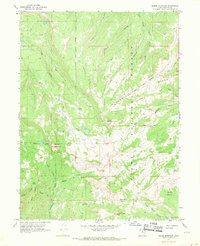
1967 Map of Heber Mountain
USGS Topo · Published 1969About this map
Heber Mountain stands as a central high point in this high-altitude landscape within the Uinta National Forest. The map documents a complex drainage system where the headwaters of several significant regional waterways emerge, including the Duchesne River, Little South Fork Provo River, and Strawberry River. A notable historical detail is the Indian Treaty Boundary, which cuts diagonally across the northeastern quadrant, reflecting the administrative and territorial divisions of the era. The terrain is characterized by high basins like Roundy Basin and Buck Basin, and prominent summits such as Currant Creek Peak and Bald Knoll. Early transportation routes are represented by the Old Duchesne Road and various jeep trails, while modern infrastructure appears as a single Radio Tower near the center of the sheet.
Find a feature on this map
39 named features on this map. Tap any name to fly to it.
Don’t see what you’re looking for? This feature index may not catch every label — zoom into the map to look around manually.
Map Details
Editions of this 1967 Heber Mountain Map
2 editions found
Other maps of this area

1885 · Salt Lake
USGS Topo · 1:250,000

1900 · Coalville
USGS Topo · 1:125,000

1903 · Coalville
USGS Topo · 1:125,000

1907 · Strawberry Valley
USGS Topo · 1:125,000

1909 · Strawberry Valley
USGS Topo · 1:125,000

1954 · Salt Lake City
USGS Topo · 1:250,000

1958 · Salt Lake City
USGS Topo · 1:250,000

1960 · Salt Lake City
USGS Topo · 1:250,000

1967 · Francis
USGS Topo · 1:24,000
1967 · Center Creek
USGS Topo · 1:24,000