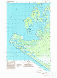
1987 Map of Yakutat C-5 SW
USGS Topo · Published 1988This historical map portrays the area of Yakutat C-5 SW in 1987, primarily covering Yakutat. Featuring a scale of 1:25000, this map provides a highly detailed snapshot of the terrain, roads, buildings, counties, and historical landmarks in the Yakutat C-5 SW region at the time. Published in 1988, it is one of 2 known editions of this map due to revisions or reprints.
Find a feature on this map
40 named features on this map. Tap any name to fly to it.
Don’t see what you’re looking for? This feature index may not catch every label — zoom into the map to look around manually.
Map Details
Editions of this 1987 Yakutat C-5 SW Map
2 editions found
Historical Maps of Yakutat Through Time
84 maps found

1948 Bering Glacier A-4
Yakutat Borough, AK

1948 Icy Bay D-2 and D-3
Yakutat Borough, AK

1950 Bering Glacier A-3
Yakutat Borough, AK

1950 Bering Glacier
Yakutat Borough, AK

1950 Icy Bay
Yakutat Borough, AK

1951 Bering Glacier A-2
Yakutat Borough, AK

1951 Bering Glacier A-4
Yakutat Borough, AK

1951 Bering Glacier
Yakutat Borough, AK

1951 Icy Bay D-2 and D-3
Yakutat Borough, AK

1951 Icy Bay
Yakutat Borough, AK

1951 Mt Saint Elias
Yakutat Borough, AK

1959 Bering Glacier A-2
Yakutat Borough, AK

1959 Bering Glacier A-3
Yakutat Borough, AK

1959 Bering Glacier A-4
Yakutat Borough, AK

1959 Bering Glacier
Yakutat Borough, AK

1959 Icy Bay D-2 and D-3
Yakutat Borough, AK

1959 Mt Saint Elias
Yakutat Borough, AK

1959 Yakutat A-1
Yakutat Borough, AK

1959 Yakutat A-2
Yakutat Borough, AK

1959 Yakutat A-3
Yakutat Borough, AK

1959 Yakutat B-1
Yakutat Borough, AK

1959 Yakutat B-2
Yakutat Borough, AK

1959 Yakutat B-3
Yakutat Borough, AK

1959 Yakutat B-4
Yakutat Borough, AK

1959 Yakutat B-5
Yakutat Borough, AK

1959 Yakutat C-3
Yakutat Borough, AK

1959 Yakutat C-4
Yakutat Borough, AK

1959 Yakutat C-5
Yakutat Borough, AK

1959 Yakutat D-3
Yakutat Borough, AK

1959 Yakutat D-4
Yakutat Borough, AK

1959 Yakutat D-5
Yakutat Borough, AK

1961 Icy Bay
Yakutat Borough, AK

1961 Mount Fairweather D-6
Yakutat Borough, AK

1961 Mount Fairweather D-7
Yakutat Borough, AK

1961 Skagway A-7
Yakutat Borough, AK

1961 Skagway A-8
Yakutat Borough, AK

1961 Skagway B-8
Yakutat Borough, AK

1984 Bering Glacier A-4
Yakutat Borough, AK

1984 Bering Glacier A-5
Yakutat Borough, AK

1984 Bering Glacier A-6
Yakutat Borough, AK

1984 Bering Glacier A-7
Yakutat Borough, AK

1984 Bering Glacier A-8
Yakutat Borough, AK

1985 Bering Glacier A-1
Yakutat Borough, AK

1985 Bering Glacier B-1
Yakutat Borough, AK

1985 Bering Glacier B-2
Yakutat Borough, AK

1985 Bering Glacier B-3
Yakutat Borough, AK

1985 Bering Glacier B-4
Yakutat Borough, AK

1985 Bering Glacier B-5
Yakutat Borough, AK

1985 Bering Glacier B-6
Yakutat Borough, AK

1985 Bering Glacier B-7
Yakutat Borough, AK

1985 Bering Glacier C-3
Yakutat Borough, AK

1985 Bering Glacier C-4
Yakutat Borough, AK

1985 Bering Glacier C-5
Yakutat Borough, AK

1985 Bering Glacier C-6
Yakutat Borough, AK

1985 Icy Bay D-1
Yakutat Borough, AK

1985 Mount Saint Elias A-3
Yakutat Borough, AK

1985 Mount Saint Elias A-4
Yakutat Borough, AK

1985 Mount Saint Elias A-5
Yakutat Borough, AK

1985 Mount Saint Elias A-6
Yakutat Borough, AK

1985 Mount Saint Elias A-7
Yakutat Borough, AK

1985 Mount Saint Elias A-8
Yakutat Borough, AK

1985 Mount Saint Elias B-3
Yakutat Borough, AK

1985 Mount Saint Elias B-4
Yakutat Borough, AK

1985 Mount Saint Elias B-5
Yakutat Borough, AK

1985 Mount Saint Elias B-7
Yakutat Borough, AK

1985 Mount Saint Elias B-8
Yakutat Borough, AK

1985 Yakutat C-1
Yakutat Borough, AK

1985 Yakutat C-2
Yakutat Borough, AK

1985 Yakutat C-6
Yakutat Borough, AK

1985 Yakutat C-7
Yakutat Borough, AK

1985 Yakutat C-8
Yakutat Borough, AK

1985 Yakutat D-2
Yakutat Borough, AK

1985 Yakutat D-6
Yakutat Borough, AK

1985 Yakutat D-7
Yakutat Borough, AK

1985 Yakutat D-8
Yakutat Borough, AK

1987 Yakutat B-4 NW
Yakutat Borough, AK

1987 Yakutat B-5 NE
Yakutat Borough, AK

1987 Yakutat C-4 SE
Yakutat Borough, AK

1987 Yakutat C-4 SW
Yakutat Borough, AK

1987 Yakutat C-5 SE
Yakutat Borough, AK

1987 Yakutat C-5 SW
Yakutat Borough, AK

1996 Yakutat C-5
Yakutat Borough, AK

1997 Yakutat B-1
Yakutat Borough, AK

1997 Yakutat C-4
Yakutat Borough, AK