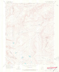
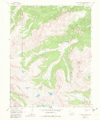
1964 Map of Rio Grande Pyramid
USGS Topo · Published 1967About this map
The Rio Grande Pyramid towers over this high-altitude landscape where the headwaters of the Rio Grande emerge within the Rio Grande National Forest. Surveyed in the mid-1960s, the terrain is defined by the Continental Divide, which snakes through the San Juan Mountains and separates the drainage basins of the Rio Grande and San Juan National Forest. A network of pack trails, including the Ute Creek Trail and East Ute Trail, provides the primary movement across these ridges, connecting remote water bodies like West Ute Lake, Middle Ute Lake, and the Flint Lakes. Named landforms such as Indian Ridge, Starvation Gulch, and The Window offer a look at the early nomenclature used by surveyors and travelers passing through the Hinsdale and San Juan county lines before modern development reached these peaks.
Find a feature on this map
35 named features on this map. Tap any name to fly to it.
Don’t see what you’re looking for? This feature index may not catch every label — zoom into the map to look around manually.
Map Details
Editions of this 1964 Rio Grande Pyramid Map
5 editions found
Other maps of this area

1897 · Silverton
USGS Topo · 1:62,500

1900 · Needle Mountains
USGS Topo · 1:62,500

1901 · Silverton
USGS Topo · 1:62,500

1902 · Needle Mountains
USGS Topo · 1:62,500

1902 · Silverton
USGS Topo · 1:62,500

1905 · San Cristobal
USGS Topo · 1:125,000

1907 · San Cristobal
USGS Topo · 1:125,000

1945 · Durango
USGS Topo · 1:250,000

1953 · Durango
USGS Topo · 1:250,000

1954 · Durango
USGS Topo · 1:250,000