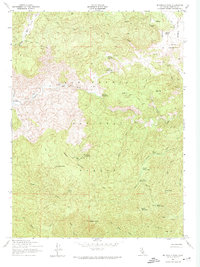
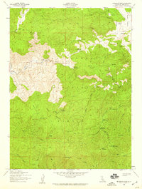
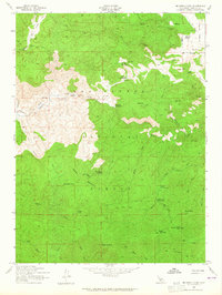
1958 Map of McDonald Peak
USGS Topo · Published 1974This historical map portrays the area of McDonald Peak in 1958, primarily covering Lassen County. Featuring a scale of 1:24000, this map provides a highly detailed snapshot of the terrain, roads, buildings, counties, and historical landmarks in the McDonald Peak region at the time. Published in 1974, it is one of 3 known editions of this map due to revisions or reprints.
Map Details
Editions of this 1958 McDonald Peak Map
3 editions found
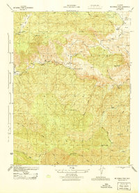
Historical Maps of Moran Through Time
131 maps found

1886 Honey Lake
Lassen County, CA

1891 Honey Lake
Lassen County, CA

1893 Honey Lake
Lassen County, CA

1939 Halls Flat
Lassen County, CA
1944 McDonald Peak
Lassen County, CA

1954 Fredonyer Peak
Lassen County, CA

1954 Grasshopper Valley
Lassen County, CA

1954 Karlo
Lassen County, CA

1954 Observation Peak
Lassen County, CA

1954 Ravendale
Lassen County, CA

1954 Shinn Mountain
Lassen County, CA

1954 Wendel
Lassen County, CA

1956 Antelope Mtn
Lassen County, CA

1956 Harvey Mtn
Lassen County, CA

1956 Hayden Hill
Lassen County, CA
1958 McDonald Peak
Lassen County, CA

1962 Boot Lake
Lassen County, CA

1962 Cold Spring Mtn
Lassen County, CA

1962 Little Hat Mtn
Lassen County, CA

1972 Diamond Mtn
Lassen County, CA

1972 Standish
Lassen County, CA

1975 Beckwourth Pass
Lassen County, CA

1975 Prospect Peak SE
Lassen County, CA

1975 Susanville NE
Lassen County, CA

1975 Susanville NW
Lassen County, CA

1977 Constantia
Lassen County, CA

1978 Mc Kesick Peak
Lassen County, CA

1978 Stony Ridge
Lassen County, CA

1979 Swain Mountain
Lassen County, CA

1980 Fredonyer Pass
Lassen County, CA

1980 Pegleg Mountain
Lassen County, CA

1980 Roop Mountain
Lassen County, CA

1980 Westwood East
Lassen County, CA

1983 Antelope Mtn
Lassen County, CA

1983 Bogard Buttes
Lassen County, CA

1983 Bullard Lake
Lassen County, CA

1983 Champs Flat
Lassen County, CA

1983 Corders Reservoir
Lassen County, CA

1983 Dixie Peak
Lassen County, CA

1983 Harvey Mountain
Lassen County, CA

1983 Pikes Point
Lassen County, CA

1983 Pine Creek Valley
Lassen County, CA

1983 Poison Lake
Lassen County, CA

1983 Said Valley
Lassen County, CA

1983 Sheepshead
Lassen County, CA

1983 Silva Flat Reservoir
Lassen County, CA

1983 Spalding Tract
Lassen County, CA

1983 Straylor Lake
Lassen County, CA

1985 Prospect Peak
Lassen County, CA

1985 Swains Hole
Lassen County, CA

1988 Bull Flat
Lassen County, CA

1988 Calneva Lake
Lassen County, CA

1988 Little Mud Flat
Lassen County, CA

1988 Shaffer Mtn
Lassen County, CA

1988 Spencer Creek
Lassen County, CA

1988 Wendel Hot Springs
Lassen County, CA

1988 Wendel
Lassen County, CA

1989 Al Shinn Canyon
Lassen County, CA

1989 Anderson Mountain
Lassen County, CA

1989 Buckhorn Canyon
Lassen County, CA

1989 Buckhorn Lake
Lassen County, CA

1989 Cherry Mountain
Lassen County, CA

1989 Cleghorn Flat
Lassen County, CA

1989 Dodge Reservoir
Lassen County, CA

1989 Five Springs
Lassen County, CA

1989 Fredonyer Peak
Lassen County, CA

1989 Gallatin Peak
Lassen County, CA

1989 Grasshopper Valley
Lassen County, CA

1989 Juniper Ridge
Lassen County, CA

1989 Karlo
Lassen County, CA

1989 McDonald Peak
Lassen County, CA

1989 Observation Peak
Lassen County, CA

1989 Petes Valley
Lassen County, CA

1989 Ravendale
Lassen County, CA

1989 Shinn Mountain
Lassen County, CA

1989 Snowstorm Mountain
Lassen County, CA

1989 Termo
Lassen County, CA

1989 Troxel Point
Lassen County, CA

1989 Tunnison Mountain
Lassen County, CA

1989 West of Snowstorm Mtn
Lassen County, CA

1989 Whitinger Mountain
Lassen County, CA

1990 Ash Valley
Lassen County, CA

1990 Coble Mountain
Lassen County, CA

1990 Hog Valley
Lassen County, CA

1990 Holbrook Canyon
Lassen County, CA

1990 Jellico
Lassen County, CA

1990 Lane Reservoir
Lassen County, CA

1990 Letterbox Hill
Lassen County, CA

1990 Pittville
Lassen County, CA

1992 Eagle Lake
Lassen County, CA

1993 Ash Valley
Lassen County, CA

1993 Boot Lake
Lassen County, CA

1993 Cold Spring Mtn
Lassen County, CA

1993 Dixie Peak
Lassen County, CA

1993 Hog Valley
Lassen County, CA

1993 Lane Reservoir
Lassen County, CA

1993 Letterbox Hill
Lassen County, CA

1993 Little Hat Mtn.
Lassen County, CA

1993 Said Valley
Lassen County, CA

1993 Silva Flat Reservoir
Lassen County, CA

1993 Whitinger Mountain
Lassen County, CA

1994 Beckwourth Pass
Lassen County, CA

1994 Constantia
Lassen County, CA

1994 Diamond Mountain
Lassen County, CA

1994 Mc Kesick Peak
Lassen County, CA

1994 Standish
Lassen County, CA

1994 Stony Ridge
Lassen County, CA

1995 Antelope Mountain
Lassen County, CA

1995 Bogard Buttes
Lassen County, CA

1995 Bullard Lake
Lassen County, CA

1995 Champs Flat
Lassen County, CA

1995 Coble Mountain
Lassen County, CA

1995 Corders Reservoir
Lassen County, CA

1995 Fredonyer Pass
Lassen County, CA

1995 Gallatin Peak
Lassen County, CA

1995 Harvey Mountain
Lassen County, CA

1995 Jellico
Lassen County, CA

1995 Pegleg Mountain
Lassen County, CA

1995 Pikes Point
Lassen County, CA

1995 Pine Creek Valley
Lassen County, CA

1995 Pittville
Lassen County, CA

1995 Poison Lake
Lassen County, CA

1995 Prospect Peak
Lassen County, CA

1995 Roop Mountain
Lassen County, CA

1995 Sheepshead
Lassen County, CA

1995 Spalding Tract
Lassen County, CA

1995 Straylor Lake
Lassen County, CA

1995 Swain Mountain
Lassen County, CA

1995 Swains Hole
Lassen County, CA

1995 Troxel Point
Lassen County, CA

1995 Westwood East
Lassen County, CA